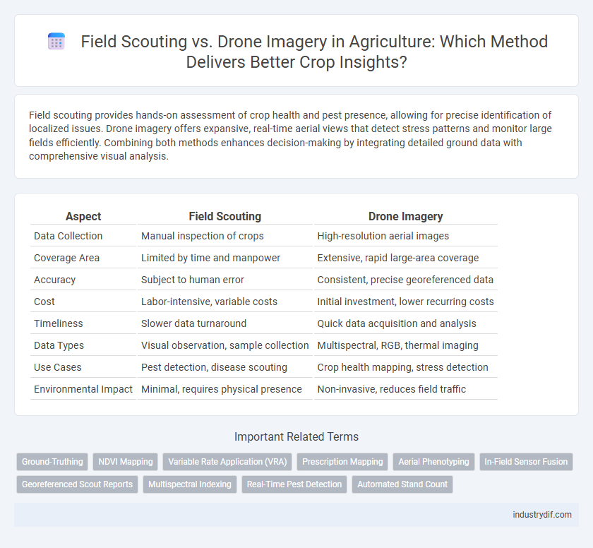
Field scouting provides hands-on assessment of crop health and pest presence, allowing for precise identification of localized issues. Drone imagery offers expansive, real-time aerial views that detect stress patterns and monitor large fields efficiently. Combining both methods enhances decision-making by integrating detailed ground data with comprehensive visual analysis.
Table of Comparison
| Aspect | Field Scouting | Drone Imagery |
|---|---|---|
| Data Collection | Manual inspection of crops | High-resolution aerial images |
| Coverage Area | Limited by time and manpower | Extensive, rapid large-area coverage |
| Accuracy | Subject to human error | Consistent, precise georeferenced data |
| Cost | Labor-intensive, variable costs | Initial investment, lower recurring costs |
| Timeliness | Slower data turnaround | Quick data acquisition and analysis |
| Data Types | Visual observation, sample collection | Multispectral, RGB, thermal imaging |
| Use Cases | Pest detection, disease scouting | Crop health mapping, stress detection |
| Environmental Impact | Minimal, requires physical presence | Non-invasive, reduces field traffic |
Introduction to Field Scouting and Drone Imagery in Agriculture
Field scouting involves manual inspection of crops to detect pests, diseases, and nutrient deficiencies, providing precise, ground-level insights critical for timely decision-making. Drone imagery utilizes aerial technology to capture high-resolution photos and multispectral data, enabling rapid assessment of large fields and early identification of stress patterns. Combining field scouting with drone imagery enhances crop monitoring accuracy, optimizing yields and resource management in modern agriculture.
Traditional Field Scouting: Methods and Tools
Traditional field scouting in agriculture relies on manual observation techniques such as walk-through inspections, soil sampling, and pest identification using handheld tools like magnifying lenses, moisture meters, and GPS devices for precise location tracking. These methods enable farmers to assess crop health, detect diseases, and monitor pest populations on a granular level, providing direct and immediate insights from the field. Despite being labor-intensive, traditional scouting remains crucial for making informed decisions about crop management and fertilizer application based on firsthand evidence.
How Drone Imagery is Revolutionizing Crop Monitoring
Drone imagery transforms crop monitoring by providing high-resolution, real-time aerial data that enables precise analysis of plant health, pest infestations, and nutrient deficiencies. Unlike traditional field scouting, drones cover extensive areas rapidly, increasing efficiency and reducing labor costs while delivering consistent, objective insights through multispectral and thermal imaging. Farmers leverage drone-generated maps to make timely decisions, optimize resource use, and improve crop yields, marking a significant advancement in precision agriculture.
Efficiency Comparison: Manual Scouting vs. Drone Surveys
Field scouting requires extensive labor and time to cover large crop areas, often resulting in delayed pest or disease detection. Drone imagery accelerates data collection by capturing high-resolution multispectral images swiftly over vast fields, enabling precise and timely analysis. This technological integration significantly improves efficiency, reduces labor costs, and enhances decision-making accuracy in modern agricultural management.
Data Accuracy: Human Observation vs. Aerial Imaging
Field scouting provides direct human observation, allowing for detailed identification of crop health, pest presence, and soil conditions, often capturing subtle signs that drones may miss. Drone imagery delivers high-resolution, multispectral data over large areas quickly, enabling comprehensive analysis of plant stress and variability with consistent repeatability. Combining both methods enhances data accuracy by merging the nuanced insights of field scouts with the broad perspective and precise measurements from aerial imaging.
Cost Analysis: Investment and ROI for Both Approaches
Field scouting requires significant labor costs due to manual crop inspection, which can limit scalability and increase operational expenses. Drone imagery demands a larger initial investment in technology and training but offers faster data collection and can cover extensive areas with high-resolution imaging, improving decision-making efficiency. Over time, drone technology often delivers a higher return on investment (ROI) through precise crop monitoring, early pest and disease detection, and optimized resource management, reducing input costs and boosting yields.
Integrating Field Scouting with Drone Technology
Integrating field scouting with drone technology enhances precision agriculture by combining on-the-ground observations with aerial data analytics to improve crop health monitoring and pest management. Drones provide high-resolution imagery and real-time data, enabling scouts to identify problem areas quickly while validating findings through direct field inspections. This synergy increases operational efficiency, reduces labor costs, and supports data-driven decision-making for optimized yield and resource use.
Limitations and Challenges of Each Method
Field scouting requires extensive labor and time, limiting the frequency and scale of crop monitoring, while it can be subjective due to human error and variable expertise. Drone imagery provides rapid data collection over large areas with high-resolution multispectral images but faces challenges such as high upfront costs, regulatory restrictions, and susceptibility to weather conditions affecting flight and image quality. Integrating both methods can help mitigate these limitations by combining detailed on-ground observations with comprehensive aerial data.
Case Studies: Real-World Results from Farms
Field scouting offers hands-on crop evaluation through direct observation, while drone imagery provides high-resolution aerial data for large-scale analysis. Case studies from farms in Iowa and California demonstrate drone imagery's ability to detect early signs of pest infestation and nutrient deficiencies, enabling timely interventions that increased yields by up to 15%. Combining traditional scouting with drone technology optimizes resource allocation and enhances decision-making in precision agriculture.
The Future of Crop Monitoring: Hybrid Solutions
Hybrid solutions combining field scouting and drone imagery revolutionize crop monitoring by enhancing precision and timeliness. Integrating on-ground observations with aerial data enables accurate pest detection, disease identification, and nutrient assessment, leading to optimized crop management. Advances in AI-powered analytics further augment decision-making, ensuring sustainable agricultural practices and increased yield.
Related Important Terms
Ground-Truthing
Field scouting provides precise ground-truthing by enabling farmers to observe crop conditions and pest presence firsthand, ensuring accurate assessment of plant health and soil status. Drone imagery offers broad spatial coverage but requires ground-truthing to validate remote sensor data and refine interpretation of crop stress indicators.
NDVI Mapping
Field scouting provides hands-on assessment of crop health and pest presence, offering detailed ground-level insights that guide precise interventions. Drone imagery, utilizing NDVI mapping, delivers rapid, high-resolution vegetation indices enabling large-scale monitoring of crop vigor, stress, and nutrient deficiencies with spatial accuracy unattainable by manual scouting.
Variable Rate Application (VRA)
Field scouting offers detailed, ground-level insights into crop health and pest behavior, enabling precise adjustments in Variable Rate Application (VRA) to optimize input use. Drone imagery provides comprehensive, high-resolution aerial data that enhances VRA accuracy through real-time monitoring of field variability and stress patterns.
Prescription Mapping
Field scouting provides detailed, ground-level insights into crop health, but drone imagery enhances prescription mapping by offering high-resolution aerial data that covers large areas quickly and precisely. Integrating multispectral drone imagery with GIS technology enables accurate identification of nutrient deficiencies, pest infestations, and irrigation needs, optimizing variable rate applications for improved yield and resource efficiency.
Aerial Phenotyping
Field scouting provides direct, ground-level insights into crop conditions but is time-consuming and limited in spatial coverage, whereas drone imagery enables rapid, high-resolution aerial phenotyping, capturing precise data on plant health, growth patterns, and stress indicators across large areas. Integrating drone-based aerial phenotyping with traditional scouting enhances crop monitoring accuracy, optimizing decision-making for yield improvement and sustainable land management.
In-Field Sensor Fusion
Field scouting integrates real-time observations with in-field sensor fusion, combining data from soil moisture sensors, weather stations, and crop health monitors to enhance precision agriculture practices. Drone imagery complements this by providing high-resolution aerial views that, when fused with ground sensor data, enable more accurate detection of pest infestations, nutrient deficiencies, and irrigation needs.
Georeferenced Scout Reports
Georeferenced scout reports enhance field scouting by providing precise location data, enabling farmers to target interventions with greater accuracy and efficiency. Drone imagery complements this by capturing high-resolution aerial views, but integrating both sources maximizes crop health monitoring and pest detection precision.
Multispectral Indexing
Field scouting provides direct, hands-on assessment of crop health, while drone imagery equipped with multispectral indexing enables precise detection of plant stress, disease, and nutrient deficiencies by analyzing reflectance patterns across specific wavelength bands. Integrating multispectral data with traditional scouting improves early diagnosis and targeted intervention, enhancing yield optimization and resource management in modern agriculture.
Real-Time Pest Detection
Field scouting allows farmers to manually inspect crops for pest infestations, providing accurate but time-consuming data collection limited by human presence. Drone imagery enables rapid, real-time pest detection over large agricultural areas using multispectral sensors and AI algorithms, enhancing early intervention and crop protection efficiency.
Automated Stand Count
Automated stand count using drone imagery enhances accuracy and efficiency in field scouting by providing precise plant population data through high-resolution aerial images processed with advanced algorithms. This technology reduces labor costs and time compared to traditional manual scouting methods, enabling farmers to make data-driven decisions for crop management and yield optimization.
Field Scouting vs Drone Imagery Infographic