High-altitude pseudo-satellites (HAPS) provide persistent surveillance by operating at altitudes between traditional drones and satellites, offering lower latency and higher resolution imagery than conventional satellite surveillance. Unlike satellites, HAPS can be repositioned quickly for real-time defense monitoring in dynamic environments, enhancing battlefield awareness. Satellite surveillance covers vast areas globally but often suffers from fixed orbits and longer revisit times, limiting immediate responsiveness.
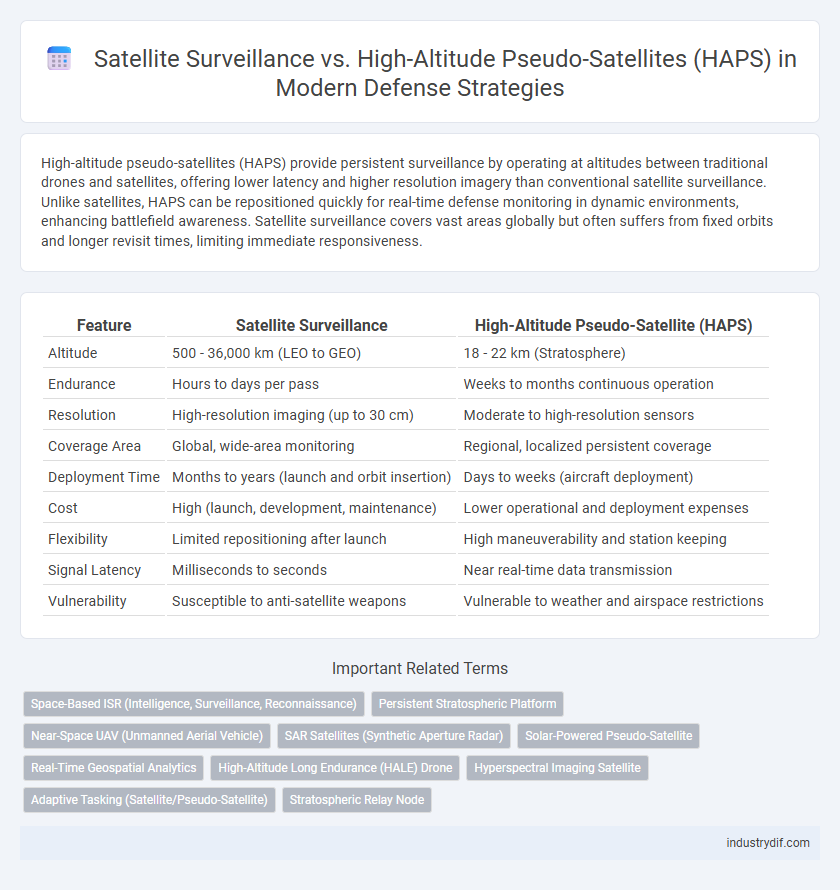
Table of Comparison
| Feature | Satellite Surveillance | High-Altitude Pseudo-Satellite (HAPS) |
|---|---|---|
| Altitude | 500 - 36,000 km (LEO to GEO) | 18 - 22 km (Stratosphere) |
| Endurance | Hours to days per pass | Weeks to months continuous operation |
| Resolution | High-resolution imaging (up to 30 cm) | Moderate to high-resolution sensors |
| Coverage Area | Global, wide-area monitoring | Regional, localized persistent coverage |
| Deployment Time | Months to years (launch and orbit insertion) | Days to weeks (aircraft deployment) |
| Cost | High (launch, development, maintenance) | Lower operational and deployment expenses |
| Flexibility | Limited repositioning after launch | High maneuverability and station keeping |
| Signal Latency | Milliseconds to seconds | Near real-time data transmission |
| Vulnerability | Susceptible to anti-satellite weapons | Vulnerable to weather and airspace restrictions |
Introduction to Satellite Surveillance and High-Altitude Pseudo-Satellites (HAPS)
Satellite surveillance employs orbiting satellites equipped with advanced sensors to monitor global activities, providing comprehensive intelligence and real-time data critical for national defense. High-Altitude Pseudo-Satellites (HAPS) operate in the stratosphere at around 20 kilometers altitude, offering persistent, low-latency observation capabilities with lower operational costs compared to traditional satellites. Both platforms enhance defense surveillance by delivering complementary aerial coverage, where satellites offer broad area monitoring and HAPS provide focused, continuous intelligence over specific regions.
Key Technological Differences between Satellites and HAPS
Satellites operate in orbit, utilizing advanced sensors and communication systems to provide global coverage with high-speed data transmission, while High-Altitude Pseudo-Satellites (HAPS) function within the stratosphere, offering persistent surveillance capabilities through solar-powered platforms with extended loitering times. The technological differences include satellites' reliance on space-based infrastructure and long-distance signal relay versus HAPS' emphasis on high-altitude endurance, lower latency, and flexible deployment in contested environments. Sensor payloads on satellites are optimized for wide-area reconnaissance, whereas HAPS often feature modular, mission-specific equipment tailored for tactical intelligence, surveillance, and reconnaissance (ISR) operations.
Operational Altitude and Coverage Comparison
Satellite surveillance operates primarily in low Earth orbit (LEO) ranging from 160 to 2,000 kilometers, providing extensive global coverage with rapid revisit times crucial for real-time intelligence and reconnaissance. High-altitude pseudo-satellites (HAPS) function within the stratosphere at altitudes between 18 to 25 kilometers, offering persistent coverage over specific regions with the advantage of lower latency and easier redeployment. The operational altitude difference between satellites and HAPS directly influences their coverage patterns, with satellites enabling broad area surveillance and HAPS excelling in continuous, focused monitoring for enhanced tactical situational awareness.
Real-Time Intelligence Gathering Capabilities
Satellite surveillance provides broad-area, global coverage with periodic revisit times, enabling comprehensive intelligence collection but with inherent latency between data captures. High-Altitude Pseudo-Satellites (HAPS), operating in the stratosphere at altitudes of approximately 20 kilometers, offer persistent, real-time monitoring capabilities over specific regions, enhancing situational awareness with continuous data transmission. The real-time intelligence gathering advantage of HAPS supports dynamic decision-making in defense operations by delivering near-instantaneous actionable information compared to traditional satellite delays.
Deployment Speed and Responsiveness
Satellite surveillance systems provide extensive coverage but are limited by longer deployment times and less flexibility in rapid response scenarios. High-altitude pseudo-satellites (HAPS) offer quicker deployment and enhanced responsiveness due to their ability to loiter over specific areas for extended periods and adjust positions dynamically. This agility makes HAPS critical for time-sensitive defense operations requiring real-time intelligence and rapid adaptation to evolving threats.
Cost Analysis: Acquisition, Launch, and Maintenance
Satellite surveillance systems incur significant acquisition and launch costs due to the complexity of orbital deployment and the need for robust, radiation-hardened components. High-altitude pseudo-satellites (HAPS) present lower acquisition and launch expenses, leveraging reusable platform technology and easier deployment at stratospheric altitudes, resulting in reduced operational budgets. Maintenance costs for satellites are generally higher because of limited in-orbit servicing capabilities, whereas HAPS allow for more frequent maintenance and upgrades given their accessibility, improving lifecycle cost efficiency in defense surveillance operations.
Survivability and Vulnerability in Contested Environments
Satellite surveillance systems offer extensive coverage and real-time intelligence but are highly vulnerable to anti-satellite weapons and cyber attacks, compromising survivability in contested environments. High-altitude pseudo-satellites (HAPS) operate within the stratosphere, providing persistent surveillance with enhanced survivability due to their mobility and reduced exposure to traditional satellite threats. The shift toward HAPS platforms enhances defense operations by mitigating vulnerabilities inherent in orbital satellites while maintaining crucial situational awareness.
Mission Flexibility and Payload Adaptability
Satellite surveillance offers extensive geographic coverage with fixed orbital paths, enabling consistent monitoring but limited mission flexibility due to predetermined trajectories. High-Altitude Pseudo-Satellites (HAPS) operate within the stratosphere, providing enhanced payload adaptability through modular designs that support real-time reconfiguration for diverse intelligence, surveillance, and reconnaissance tasks. The ability of HAPS to loiter over targeted areas for extended durations allows for tailored mission profiles, surpassing traditional satellite constraints in dynamic operational environments.
Policy, Regulatory, and Airspace Considerations
Satellite surveillance operates within well-established international frameworks governed by the Outer Space Treaty, ensuring the peaceful use of outer space and national sovereignty limits, while high-altitude pseudo-satellites (HAPS) face evolving regulatory challenges involving both aviation authorities and space agencies due to their straddling of airspace and near-space domains. Airspace considerations for HAPS include compliance with aviation safety regulations and coordination with civil and military air traffic control to prevent interference and ensure operational security. Policy development is focusing on integrating HAPS into existing defense architectures by addressing spectrum allocation, data privacy, and dual-use technology controls to harmonize with satellite surveillance systems.
Future Trends and Integration in Modern Defense Strategies
Satellite surveillance continues to evolve with advancements in high-resolution imaging and real-time data analysis, enhancing global situational awareness for defense operations. High-altitude pseudo-satellites (HAPS), operating in the stratosphere, provide persistent, cost-effective monitoring with reduced latency and improved flexibility compared to traditional satellites. Emerging defense strategies emphasize integrating satellite and HAPS technologies to create a comprehensive, multi-layered surveillance network supporting rapid decision-making and enhanced battlefield intelligence.
Related Important Terms
Space-Based ISR (Intelligence, Surveillance, Reconnaissance)
Space-based ISR leverages satellite surveillance for global, real-time intelligence gathering, providing comprehensive coverage and long-term data persistence. In contrast, high-altitude pseudo-satellites (HAPS) offer enhanced sensor resolution and prolonged loiter time over specific regions, delivering flexible, cost-effective reconnaissance in contested environments.
Persistent Stratospheric Platform
Persistent Stratospheric Platforms (PSPs) offer continuous, cost-effective surveillance compared to traditional satellites by operating at altitudes around 20 kilometers, enabling extended monitoring without orbital constraints. PSPs enhance real-time intelligence gathering and improve response times in defense operations, bridging the gap between satellite surveillance and airborne systems.
Near-Space UAV (Unmanned Aerial Vehicle)
Near-Space UAVs operating as High-Altitude Pseudo-Satellites (HAPS) provide persistent, low-latency surveillance capabilities that complement traditional satellite reconnaissance by offering enhanced maneuverability and real-time data relay in contested environments. These platforms bridge the operational gap between low Earth orbit satellites and conventional UAVs, delivering critical intelligence, surveillance, and reconnaissance (ISR) with reduced orbital dependency and improved endurance in near-space altitudes of 20 to 30 kilometers.
SAR Satellites (Synthetic Aperture Radar)
SAR satellites provide all-weather, day-and-night high-resolution imaging capabilities essential for real-time defense surveillance, outperforming High-Altitude Pseudo-Satellites (HAPS) which offer extended loiter time but limited imaging precision. The synthetic aperture radar technology enables SAR satellites to detect ground movements, track mobile targets, and penetrate cloud cover or foliage, making them crucial for tactical reconnaissance and threat assessment in modern defense strategies.
Solar-Powered Pseudo-Satellite
Solar-powered high-altitude pseudo-satellites (HAPS) provide persistent, cost-effective surveillance capabilities by operating at stratospheric altitudes for months without refueling, outperforming traditional satellites in flexibility and rapid deployment. Unlike conventional satellite systems relying on orbits and expensive launch procedures, solar-powered pseudo-satellites deliver continuous real-time intelligence, reconnaissance, and communication support crucial for modern defense operations.
Real-Time Geospatial Analytics
Satellite surveillance provides extensive real-time geospatial analytics through global coverage and rapid data relay, essential for dynamic threat detection and situational awareness. High-altitude pseudo-satellites enhance continuous monitoring capabilities by hovering in stratospheric altitudes, offering persistent, high-resolution imagery and reduced latency critical for tactical defense operations.
High-Altitude Long Endurance (HALE) Drone
High-Altitude Long Endurance (HALE) drones provide continuous, cost-effective, and flexible surveillance over vast areas, offering persistent intelligence gathering without orbital constraints typical of satellite systems. Equipped with advanced sensors and long-lasting power sources, HALE drones enhance real-time reconnaissance and battlefield awareness, complementing satellite surveillance by filling gaps in coverage and response time.
Hyperspectral Imaging Satellite
Hyperspectral imaging satellites provide critical multispectral data from space, enabling real-time, high-resolution surveillance for defense applications by detecting and analyzing spectral signatures beyond visible light. High-altitude pseudo-satellites (HAPS) complement these capabilities by offering persistent, lower-cost monitoring with enhanced flexibility in battlefield environments, yet they typically lack the advanced spectral range and orbital coverage of hyperspectral imaging satellites.
Adaptive Tasking (Satellite/Pseudo-Satellite)
Adaptive tasking in satellite surveillance enables dynamic reallocation of imaging and monitoring resources based on real-time intelligence, enhancing responsiveness to emerging threats. High-altitude pseudo-satellites (HAPS) provide persistent, flexible coverage with rapid retasking capabilities, complementing traditional satellites by reducing latency and improving situational awareness in defense operations.
Stratospheric Relay Node
Satellite surveillance offers wide-area, real-time monitoring capabilities from low Earth orbit, while high-altitude pseudo-satellites (HAPS) operating as stratospheric relay nodes provide persistent, flexible communication links with reduced latency and lower operational costs. Stratospheric relay nodes enhance defense networks by bridging communication gaps between ground units and satellites, enabling improved situational awareness and faster data transmission in contested environments.
Satellite Surveillance vs High-Altitude Pseudo-Satellite Infographic