Satellite imagery provides broad, high-resolution visual data crucial for large-scale defense monitoring, while hyperspectral imaging offers detailed spectral information that detects material composition and subtle changes on the battlefield. Hyperspectral sensors capture data across multiple wavelengths, enabling precise identification of camouflage, concealed objects, and environmental conditions that standard satellite imagery might miss. Combining both technologies enhances situational awareness and threat detection, improving defense strategies and response capabilities.
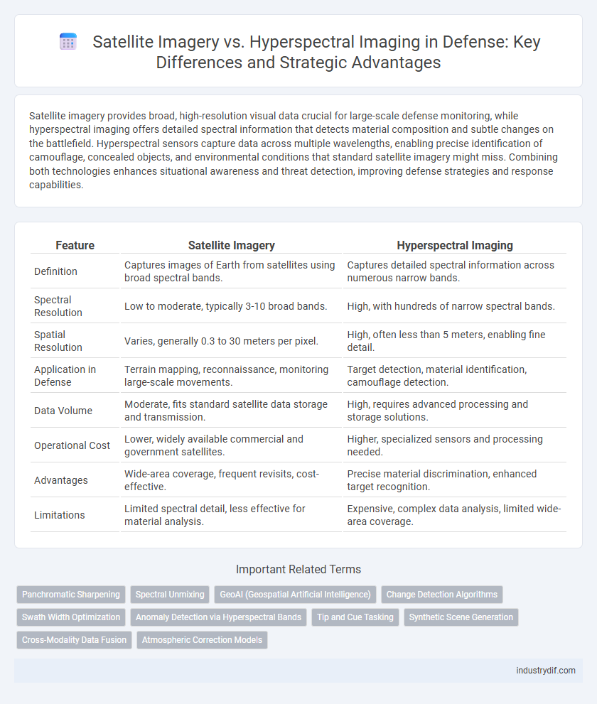
Table of Comparison
| Feature | Satellite Imagery | Hyperspectral Imaging |
|---|---|---|
| Definition | Captures images of Earth from satellites using broad spectral bands. | Captures detailed spectral information across numerous narrow bands. |
| Spectral Resolution | Low to moderate, typically 3-10 broad bands. | High, with hundreds of narrow spectral bands. |
| Spatial Resolution | Varies, generally 0.3 to 30 meters per pixel. | High, often less than 5 meters, enabling fine detail. |
| Application in Defense | Terrain mapping, reconnaissance, monitoring large-scale movements. | Target detection, material identification, camouflage detection. |
| Data Volume | Moderate, fits standard satellite data storage and transmission. | High, requires advanced processing and storage solutions. |
| Operational Cost | Lower, widely available commercial and government satellites. | Higher, specialized sensors and processing needed. |
| Advantages | Wide-area coverage, frequent revisits, cost-effective. | Precise material discrimination, enhanced target recognition. |
| Limitations | Limited spectral detail, less effective for material analysis. | Expensive, complex data analysis, limited wide-area coverage. |
Introduction to Satellite Imagery and Hyperspectral Imaging
Satellite imagery captures high-resolution optical images from space, enabling real-time monitoring of vast geographic regions for defense applications such as reconnaissance and target identification. Hyperspectral imaging collects data across numerous spectral bands beyond visible light, revealing material composition and camouflage detection undetectable by conventional imaging. Combining satellite imagery with hyperspectral data enhances situational awareness, threat analysis, and precision targeting in modern defense strategies.
Core Principles: How Satellite Imagery Works
Satellite imagery captures visual data by detecting reflected sunlight or emitted thermal radiation from Earth's surface using sensors aboard satellites. It relies on optical sensors that operate across various spectral bands, mainly visible and infrared, to generate high-resolution images which support reconnaissance and surveillance. This remote sensing technique provides spatial context crucial for monitoring terrain, infrastructure, and movement in defense operations.
Fundamentals of Hyperspectral Imaging Technology
Hyperspectral imaging technology captures and processes information across hundreds of narrow spectral bands, enabling detailed analysis of material composition beyond the capabilities of conventional satellite imagery, which primarily relies on multispectral data. This advanced spectral resolution allows defense analysts to detect subtle changes in terrain, camouflage, and chemical signatures crucial for surveillance and reconnaissance. By leveraging hyperspectral sensors, military operations achieve enhanced target identification, threat assessment, and environmental monitoring in various tactical scenarios.
Spatial and Spectral Resolution: Key Differences
Satellite imagery provides high spatial resolution, capturing detailed images of large areas essential for strategic defense surveillance, while hyperspectral imaging excels in spectral resolution, detecting material composition through hundreds of narrow spectral bands. The key difference lies in spatial versus spectral data richness: satellite imagery offers precise location and shape information, whereas hyperspectral imaging enables identification of objects based on their unique spectral signatures. Combining both technologies enhances defense capabilities by integrating detailed spatial context with advanced material discrimination for improved threat detection and battlefield analysis.
Data Acquisition and Processing Techniques
Satellite imagery captures broad-spectrum data using multispectral sensors, allowing for wide-area surveillance with relatively fast data acquisition and lower processing complexity. Hyperspectral imaging collects data across hundreds of narrow spectral bands, enabling detailed analysis for material identification but requires advanced processing techniques like spectral unmixing and dimensionality reduction to handle large datasets. In defense applications, integrating satellite imagery with hyperspectral data enhances target detection accuracy and situational awareness through complementary spatial and spectral information.
Defense Applications: Intelligence, Surveillance, and Reconnaissance
Satellite imagery provides broad-area surveillance with high-resolution visual data, essential for tracking troop movements and large-scale battlefield changes. Hyperspectral imaging enables detailed analysis of materials and terrain by capturing spectral signatures across numerous wavelengths, improving target identification and threat detection in camouflage or obscured environments. Combining these technologies enhances intelligence, surveillance, and reconnaissance (ISR) capabilities by delivering both spatial context and spectral detail crucial for mission-critical defense operations.
Advantages and Limitations of Satellite Imagery in Defense
Satellite imagery in defense offers broad-area surveillance and real-time monitoring capabilities, enabling the detection of large-scale troop movements and infrastructure changes across diverse terrains. Its advantages include wide coverage, frequent revisits, and high-resolution optical and radar sensors that support strategic intelligence and early warning systems. Limitations involve susceptibility to cloud cover and weather conditions, lower spectral resolution compared to hyperspectral imaging, and constrained detection of subtle material differences critical for identifying camouflage or concealed threats.
Strategic Benefits of Hyperspectral Imaging for Military Operations
Hyperspectral imaging provides military operations with enhanced situational awareness by capturing detailed spectral information across multiple wavelengths, enabling precise identification of materials, camouflage, and concealed objects. Unlike traditional satellite imagery, hyperspectral data allows for real-time detection of chemical signatures, troop movements, and weapon systems, improving threat assessment and decision-making accuracy. These strategic benefits support targeted surveillance, mission planning, and battlefield intelligence, significantly boosting operational effectiveness in complex environments.
Integration Challenges and Cost Considerations
Satellite imagery and hyperspectral imaging integration in defense systems faces challenges due to differences in spatial, spectral resolution, and data volume, complicating seamless fusion and real-time analysis. Hyperspectral sensors generate vast datasets requiring advanced processing power and storage, significantly increasing costs compared to conventional satellite imagery. Budget constraints and the need for specialized infrastructure often limit widespread adoption despite the enhanced target detection and material discrimination capabilities hyperspectral imaging provides.
Future Trends and Innovations in Defense Imaging Technologies
Future trends in defense imaging technologies emphasize the integration of satellite imagery with hyperspectral imaging to enhance target detection and identification accuracy. Hyperspectral sensors provide detailed spectral data across numerous bands, enabling superior material discrimination compared to traditional satellite imagery. Innovations focus on real-time data processing and AI-driven analytics to improve battlefield awareness and decision-making capabilities.
Related Important Terms
Panchromatic Sharpening
Panchromatic sharpening enhances the spatial resolution of multispectral satellite imagery by merging high-resolution panchromatic data, crucial for precise target identification and battlefield situational awareness in defense applications. Hyperspectral imaging complements this by providing detailed spectral signatures across numerous bands, enabling advanced material discrimination and threat detection when fused with sharpened imagery.
Spectral Unmixing
Spectral unmixing in hyperspectral imaging provides defense analysts with high-resolution material identification by decomposing pixel signatures into constituent spectra, enabling precise target detection beyond the capabilities of conventional satellite imagery. This technique enhances situational awareness through detailed battlefield characterization, offering critical advantages in identifying camouflaged threats and differentiating between natural and man-made objects.
GeoAI (Geospatial Artificial Intelligence)
Satellite imagery provides broad, high-resolution visuals critical for surveillance and reconnaissance, while hyperspectral imaging captures detailed spectral data enabling material identification and anomaly detection in defense applications. Integration of GeoAI leverages machine learning algorithms to analyze these datasets, enhancing threat detection, terrain assessment, and strategic decision-making capabilities with unprecedented precision.
Change Detection Algorithms
Change detection algorithms in satellite imagery leverage multispectral data to identify temporal variations in terrain or structures, crucial for battlefield monitoring and threat assessment. Hyperspectral imaging enhances this capability by capturing spectral signatures across numerous wavelengths, enabling more precise material differentiation and anomaly detection vital for intelligence and reconnaissance operations.
Swath Width Optimization
Satellite imagery offers broader swath widths ideal for wide-area surveillance in defense operations, enabling rapid coverage of extensive territories. Hyperspectral imaging provides narrower swath widths but enhances target identification and material differentiation, optimizing swath width for precision reconnaissance.
Anomaly Detection via Hyperspectral Bands
Hyperspectral imaging enhances anomaly detection in defense by capturing detailed spectral signatures across numerous bands, enabling differentiation of materials and hidden objects that satellite imagery often misses due to limited spectral resolution. Exploiting hyperspectral bands facilitates identification of camouflaged threats and concealed structures through precise spectral anomaly detection, improving situational awareness and threat assessment accuracy.
Tip and Cue Tasking
Satellite imagery provides broad-spectrum visual data for general surveillance, while hyperspectral imaging captures detailed spectral signatures enabling precise material identification; focused tip and cue tasking leverages hyperspectral data to direct satellite sensors towards specific targets for enhanced threat detection and assessment. Integrating hyperspectral cues with satellite platforms significantly improves target discrimination and situational awareness in defense operations.
Synthetic Scene Generation
Synthetic scene generation in defense leverages satellite imagery to create realistic geospatial environments for training and simulation, while hyperspectral imaging enhances these models by incorporating detailed spectral signatures for improved target detection and material identification. Combining high-resolution satellite data with hyperspectral spectral diversity enables the development of advanced synthetic scenes that support more accurate battlefield analysis and decision-making.
Cross-Modality Data Fusion
Cross-modality data fusion in defense leverages satellite imagery's broad spatial coverage combined with hyperspectral imaging's detailed spectral analysis to enhance target detection and material identification. Integrating these data sources improves situational awareness and threat assessment accuracy across diverse operational environments.
Atmospheric Correction Models
Satellite imagery relies on conventional atmospheric correction models such as MODTRAN to account for atmospheric disturbances, whereas hyperspectral imaging employs advanced spectral unmixing techniques combined with physics-based atmospheric models for more precise correction. This enhanced correction capability in hyperspectral imaging significantly improves target detection accuracy and material identification in defense applications.
Satellite Imagery vs Hyperspectral Imaging Infographic