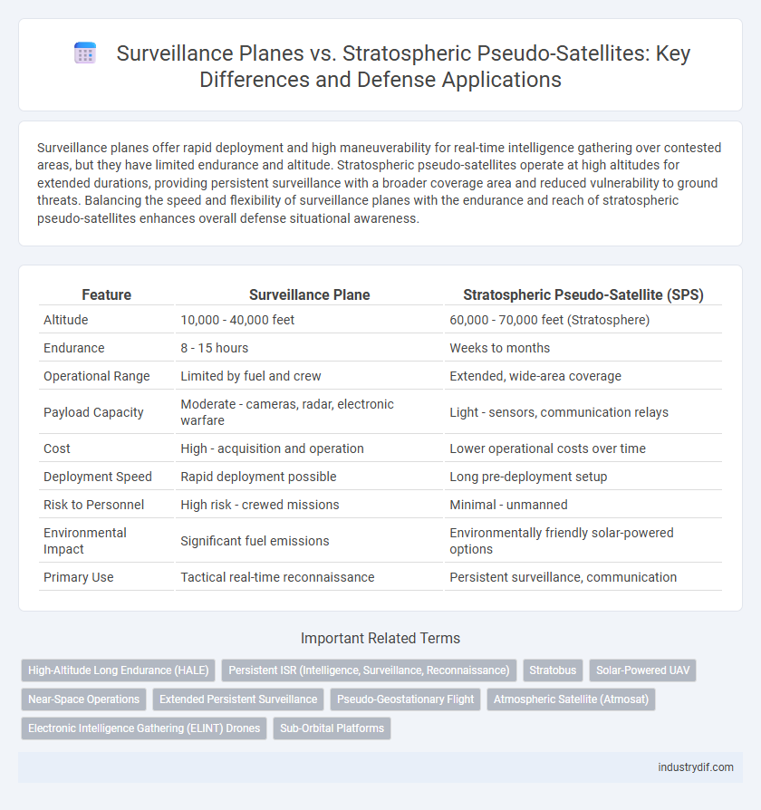
Surveillance planes offer rapid deployment and high maneuverability for real-time intelligence gathering over contested areas, but they have limited endurance and altitude. Stratospheric pseudo-satellites operate at high altitudes for extended durations, providing persistent surveillance with a broader coverage area and reduced vulnerability to ground threats. Balancing the speed and flexibility of surveillance planes with the endurance and reach of stratospheric pseudo-satellites enhances overall defense situational awareness.
Table of Comparison
| Feature | Surveillance Plane | Stratospheric Pseudo-Satellite (SPS) |
|---|---|---|
| Altitude | 10,000 - 40,000 feet | 60,000 - 70,000 feet (Stratosphere) |
| Endurance | 8 - 15 hours | Weeks to months |
| Operational Range | Limited by fuel and crew | Extended, wide-area coverage |
| Payload Capacity | Moderate - cameras, radar, electronic warfare | Light - sensors, communication relays |
| Cost | High - acquisition and operation | Lower operational costs over time |
| Deployment Speed | Rapid deployment possible | Long pre-deployment setup |
| Risk to Personnel | High risk - crewed missions | Minimal - unmanned |
| Environmental Impact | Significant fuel emissions | Environmentally friendly solar-powered options |
| Primary Use | Tactical real-time reconnaissance | Persistent surveillance, communication |
Introduction to Surveillance Planes and Stratospheric Pseudo-Satellites
Surveillance planes are manned or unmanned aircraft equipped with advanced sensors and radar systems designed for real-time intelligence, reconnaissance, and monitoring missions over diverse terrains. Stratospheric pseudo-satellites (SPS) are high-altitude, long-endurance platforms operating in the stratosphere, combining satellite-like coverage with persistence and lower latency for wide-area surveillance. These technologies complement each other by balancing the high mobility and rapid deployment of surveillance planes with the extended on-station time and broad coverage of SPS platforms.
Core Definitions: Surveillance Plane vs. Stratospheric Pseudo-Satellite
Surveillance planes are manned or unmanned aircraft designed for real-time intelligence gathering and reconnaissance missions, equipped with advanced sensors and radar systems to monitor ground activities over extensive areas. Stratospheric pseudo-satellites (SPS) are high-altitude unmanned aerial vehicles operating in the stratosphere for prolonged periods, providing persistent surveillance and communication relay capabilities that bridge the gap between satellites and traditional drones. While surveillance planes offer flexibility and rapid deployment, SPS platforms deliver endurance and continuous coverage with reduced operational costs.
Operational Altitude and Coverage Capabilities
Surveillance planes typically operate at altitudes of 20,000 to 40,000 feet, providing flexible but limited coverage areas constrained by fuel capacity and flight duration. Stratospheric pseudo-satellites function at much higher altitudes, around 65,000 to 80,000 feet in the stratosphere, enabling persistent surveillance over expansive regions for weeks or months. The extended operational altitude of pseudo-satellites enhances line-of-sight communication and sensor range, significantly increasing coverage capabilities compared to traditional surveillance aircraft.
Endurance and Mission Duration Comparison
Surveillance planes typically offer mission durations ranging from 8 to 20 hours, limited by fuel capacity and crew endurance, while stratospheric pseudo-satellites (PSPs) can sustain continuous operations for weeks or even months at altitudes around 65,000 feet. PSPs leverage solar power and advanced energy storage to maintain uninterrupted surveillance missions far beyond the endurance limits of manned aircraft. This extended mission duration significantly enhances persistent intelligence, surveillance, and reconnaissance (ISR) capabilities critical for defense operations.
Sensor Payloads and Surveillance Capabilities
Surveillance planes typically carry a diverse array of sensor payloads, including Synthetic Aperture Radar (SAR), electro-optical/infrared (EO/IR) cameras, and signals intelligence (SIGINT) equipment, enabling multi-spectral reconnaissance and real-time target tracking across vast battlefields. Stratospheric pseudo-satellites (SPS), operating at altitudes around 20 km, are equipped with high-resolution imaging sensors, persistent radar systems, and communication relays designed for long-endurance missions that provide continuous wide-area surveillance and enhance situational awareness over strategic regions. The sensor payloads on SPS platforms prioritize endurance and persistent coverage, while surveillance aircraft emphasize sensor versatility and rapid deployment for dynamic operational scenarios.
Deployment Scenarios: Use Cases in Modern Defense
Surveillance planes excel in rapid deployment for tactical reconnaissance and real-time battlefield intelligence, offering flexibility in diverse combat zones. Stratospheric pseudo-satellites provide persistent, wide-area coverage ideal for prolonged monitoring and communication relay over remote or contested regions. Military operations increasingly integrate these platforms to optimize situational awareness, with surveillance planes enhancing immediate tactical decisions and stratospheric pseudo-satellites supporting strategic command and control.
Cost Analysis: Acquisition, Operation, and Maintenance
Surveillance planes typically have higher acquisition costs ranging from $20 million to over $100 million depending on model and payload, while stratospheric pseudo-satellites (HAPS) generally cost between $1 million to $10 million due to simpler airframe and solar-electric propulsion. Operational expenses for surveillance planes include fuel, crew salaries, and airbase support, averaging millions annually, whereas HAPS operation relies on solar energy, significantly reducing fuel and maintenance costs over a 5-10 year mission duration. Maintenance for surveillance aircraft involves regular overhauls and parts replacement, often exceeding $1 million per year, contrasting with stratospheric pseudo-satellites' minimal maintenance requirements enabled by autonomous systems and high-altitude endurance.
Advantages and Limitations of Each System
Surveillance planes offer rapid deployment, flexible mission profiles, and extensive payload capacity, enabling real-time intelligence and multi-sensor integration for dynamic battlefield awareness. However, their operational range and endurance are limited by fuel capacity and airspace restrictions, making prolonged surveillance challenging. Stratospheric pseudo-satellites excel with extended loiter times, high-altitude persistence above commercial air traffic, and reduced detection risk, but they face constraints in payload weight, vulnerability to stratospheric weather conditions, and slower response times compared to traditional aircraft.
Integration with Network-Centric Warfare Systems
Surveillance planes provide real-time, high-resolution intelligence with rapid deployment capabilities, seamlessly integrating into network-centric warfare systems through advanced data links and secure communication protocols. Stratospheric pseudo-satellites (HAPS) offer persistent, wide-area coverage from near-space altitudes, acting as airborne nodes to extend network reach and enhance situational awareness over contested environments. Both platforms contribute complementary layers to integrated command and control architectures, enabling a resilient and adaptive information dominance network.
Future Trends and Technological Advancements in Aerial Surveillance
Emerging trends in aerial surveillance emphasize the integration of advanced sensor fusion and AI-driven analytics in both surveillance planes and stratospheric pseudo-satellites to enhance real-time intelligence and target acquisition accuracy. Stratospheric pseudo-satellites, leveraging solar-powered endurance and high-altitude platform stability, offer persistent coverage that challenges traditional manned surveillance planes limited by fuel and crew endurance. Future advancements focus on seamless interoperability between orbital, stratospheric, and airborne assets, enabled by 5G and satellite communication networks, to create a resilient and multi-layered aerial surveillance architecture.
Related Important Terms
High-Altitude Long Endurance (HALE)
Surveillance planes equipped with HALE capabilities offer rapid deployment and versatile mission adaptability across various altitudes, whereas stratospheric pseudo-satellites maintain persistent high-altitude presence exceeding 65,000 feet, enabling continuous intelligence, surveillance, and reconnaissance (ISR) over extended periods. HALE surveillance platforms provide critical real-time data for defense operations, while stratospheric pseudo-satellites enhance strategic coverage with minimal operational costs and reduced vulnerability to conventional threats.
Persistent ISR (Intelligence, Surveillance, Reconnaissance)
Surveillance planes provide flexible, manned ISR operations with real-time data collection over target areas but face limitations in endurance and operational costs. Stratospheric pseudo-satellites deliver persistent, high-altitude ISR coverage lasting weeks or months, enhancing situational awareness with reduced logistical support and lower detection risk in contested environments.
Stratobus
Stratobus, a cutting-edge stratospheric pseudo-satellite, offers extended endurance and high-altitude surveillance capabilities surpassing traditional surveillance planes by maintaining station for months at altitudes around 20 km. Equipped with advanced sensors and communication systems, Stratobus enhances persistent intelligence, surveillance, and reconnaissance (ISR) missions while reducing operational costs and risks associated with manned aircraft.
Solar-Powered UAV
Solar-powered UAVs in defense offer extended endurance and cost efficiency compared to traditional surveillance planes, leveraging high-altitude operations for persistent intelligence, surveillance, and reconnaissance (ISR). Stratospheric pseudo-satellites (SPS) provide near-space coverage with advanced communication capabilities, bridging the gap between satellites and manned aircraft while maintaining solar-powered sustainability for long-duration missions.
Near-Space Operations
Surveillance planes provide tactical flexibility with real-time data collection through manned systems operating at altitudes of 40,000 to 50,000 feet, while stratospheric pseudo-satellites (SPS) offer persistent intelligence, surveillance, and reconnaissance (ISR) capabilities by maintaining station at near-space altitudes around 60,000 to 70,000 feet for weeks or months. Near-space operations leverage SPS platforms' endurance and wide-area coverage to complement surveillance planes, enhancing situational awareness and reducing operational costs in extended defense missions.
Extended Persistent Surveillance
Surveillance planes provide flexible, real-time intelligence gathering with rapid deployment and high payload capacity, enabling detailed extended persistent surveillance over dynamic operational areas. Stratospheric pseudo-satellites (HAPS) offer prolonged endurance and wide-area coverage from high altitudes, maintaining continuous overwatch for weeks or months, ideal for strategic extended persistent surveillance with minimal logistical support.
Pseudo-Geostationary Flight
Surveillance planes operate at lower altitudes with flexible mission profiles, while stratospheric pseudo-satellites leverage pseudo-geostationary flight at approximately 20 kilometers, enabling prolonged persistence and near-fixed positioning over strategic areas. The pseudo-geostationary flight mode enhances continuous intelligence, surveillance, and reconnaissance (ISR) by maintaining high-altitude station-keeping with reduced radar detectability and minimal orbital mechanics constraints.
Atmospheric Satellite (Atmosat)
Atmospheric Satellites (Atmosats) operate in the stratosphere, offering persistent surveillance capabilities between traditional drones and orbital satellites, combining high-altitude endurance with lower latency data transmission. Unlike surveillance planes constrained by limited flight duration and higher operational costs, Atmosats maintain continuous coverage for intelligence, reconnaissance, and communication support in defense applications.
Electronic Intelligence Gathering (ELINT) Drones
Surveillance planes equipped with advanced Electronic Intelligence Gathering (ELINT) systems offer high-altitude, long-range signal interception but face limitations in operational endurance and vulnerability to anti-air threats. Stratospheric pseudo-satellites (HAPS) provide persistent ELINT coverage with extended loiter times and lower operational costs, enabling continuous electronic signal detection and analysis from near-space altitudes.
Sub-Orbital Platforms
Surveillance planes offer flexible, lower-altitude reconnaissance with rapid deployment capabilities, while stratospheric pseudo-satellites (HAPS) provide persistent, high-altitude coverage above 60,000 feet, bridging gaps between traditional drones and satellites for extended mission endurance. Sub-orbital platforms leverage both technologies to optimize surveillance by combining the speed and maneuverability of aircraft with the prolonged operational time and wide-area monitoring of stratospheric assets.
Surveillance Plane vs Stratospheric Pseudo-Satellite Infographic