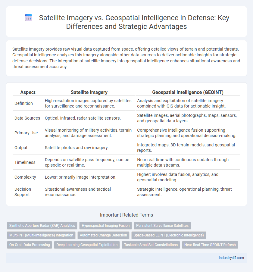
Satellite imagery provides raw visual data captured from space, offering detailed views of terrain and potential threats. Geospatial intelligence analyzes this imagery alongside other data sources to deliver actionable insights for strategic defense decisions. The integration of satellite imagery into geospatial intelligence enhances situational awareness and threat assessment accuracy.
Table of Comparison
| Aspect | Satellite Imagery | Geospatial Intelligence (GEOINT) |
|---|---|---|
| Definition | High-resolution images captured by satellites for surveillance and reconnaissance. | Analysis and exploitation of satellite imagery combined with GIS data for actionable insight. |
| Data Sources | Optical, infrared, radar satellite sensors. | Satellite images, aerial photographs, maps, sensors, and geospatial data layers. |
| Primary Use | Visual monitoring of military activities, terrain analysis, and damage assessment. | Comprehensive intelligence fusion supporting strategic planning and operational decision-making. |
| Output | Satellite photos and raw imagery. | Integrated maps, 3D terrain models, and geospatial reports. |
| Timeliness | Depends on satellite pass frequency; can be episodic or real-time. | Near real-time with continuous updates through multiple data streams. |
| Complexity | Lower; primarily image interpretation. | Higher; involves data fusion, analytics, and geospatial modeling. |
| Decision Support | Situational awareness and tactical reconnaissance. | Strategic intelligence, operational planning, threat assessment. |
Defining Satellite Imagery in Defense
Satellite imagery serves as a crucial tool in defense by providing high-resolution images captured from space-based sensors to monitor and analyze terrestrial and maritime environments. This data enables military strategists to detect enemy movements, assess battlefield conditions, and support precision targeting with real-time visual information. The integration of satellite imagery enhances situational awareness, force protection, and decision-making in complex operational theaters.
Understanding Geospatial Intelligence (GEOINT)
Geospatial Intelligence (GEOINT) integrates satellite imagery with other data sources such as maps, terrain models, and human activity patterns to provide comprehensive situational awareness for defense operations. Unlike raw satellite imagery, GEOINT analyzes spatial and temporal data to inform decision-making through predictive insights and threat identification. This multidimensional approach enhances targeting accuracy, mission planning, and real-time battlefield management.
Key Differences Between Satellite Imagery and GEOINT
Satellite imagery provides raw visual data captured from space, offering high-resolution photographs of terrain and objects, while Geospatial Intelligence (GEOINT) integrates this imagery with additional data such as maps, sensor inputs, and analysis to deliver actionable insights for defense operations. Satellite imagery focuses on capturing static images, whereas GEOINT encompasses dynamic interpretation, pattern analysis, and context evaluation to support decision-making in military strategy. GEOINT's value lies in its ability to synthesize multiple data sources, enabling comprehensive situational awareness beyond the capabilities of standalone satellite images.
The Role of Satellite Data in Military Operations
Satellite data plays a critical role in military operations by providing real-time geospatial intelligence essential for surveillance, reconnaissance, and target acquisition. High-resolution satellite imagery enables accurate mapping of terrain, identification of enemy positions, and monitoring of troop movements, enhancing situational awareness and decision-making. Integrating satellite imagery with geospatial intelligence systems improves threat detection and supports strategic planning in defense missions.
How GEOINT Enhances situational Awareness
Geospatial intelligence (GEOINT) integrates satellite imagery with advanced spatial analytics and real-time data to deliver comprehensive situational awareness critical for defense operations. This fusion enables precise mapping of enemy positions, terrain analysis, and prediction of movement patterns, vastly improving decision-making accuracy. GEOINT's ability to combine multisource data ensures timely, actionable intelligence that surpasses the capabilities of raw satellite imagery alone.
Integration of Satellite Imagery into GEOINT Workflows
Integration of satellite imagery into geospatial intelligence (GEOINT) workflows enhances real-time analysis and decision-making for defense operations by providing high-resolution, multi-spectral data. Advanced image processing techniques and machine learning algorithms optimize the fusion of satellite imagery with other geospatial datasets, improving target identification and threat assessment. This seamless integration supports comprehensive situational awareness, enabling precise mission planning and rapid response in complex operational environments.
Technological Advancements in Remote Sensing
Technological advancements in remote sensing have significantly enhanced both satellite imagery and geospatial intelligence, enabling higher resolution and real-time data acquisition. Modern satellites equipped with multispectral and hyperspectral sensors provide critical insights for defense operations by detecting subtle changes on the ground and improving target identification. Integration of artificial intelligence and machine learning algorithms further refines the analysis of geospatial data, facilitating rapid decision-making and strategic military planning.
Applications of Satellite Imagery in Defense Strategy
Satellite imagery plays a crucial role in defense strategy by providing real-time reconnaissance, surveillance, and target acquisition capabilities over vast and remote areas. It enhances situational awareness through high-resolution images used for monitoring troop movements, assessing battlefield damage, and detecting missile launches or other hostile activities. Integrating satellite imagery with geospatial intelligence enables military planners to analyze terrain, optimize troop deployments, and conduct precise mission planning for improved operational effectiveness.
GEOINT’s Impact on Decision-Making and Threat Analysis
Geospatial intelligence (GEOINT) integrates satellite imagery with geographic information systems to provide comprehensive situational awareness in defense operations. GEOINT enhances decision-making by delivering timely, accurate, and actionable insights into terrain, infrastructure, and potential adversarial movements. This fusion of data accelerates threat analysis, enabling military strategists to anticipate and counteract threats with higher precision and effectiveness.
Future Trends: The Evolving Relationship Between Satellite Imagery and GEOINT
Advancements in satellite imagery are significantly enhancing geospatial intelligence (GEOINT) capabilities by providing higher-resolution data, more frequent updates, and improved multispectral analysis. Emerging technologies such as artificial intelligence and machine learning are increasingly integrated to automate image processing and extract actionable insights from vast geospatial datasets. The future of defense intelligence relies on synergizing satellite imagery with advanced GEOINT analytics to support real-time decision-making and predictive threat assessments.
Related Important Terms
Synthetic Aperture Radar (SAR) Analytics
Satellite imagery provides high-resolution optical data primarily useful during daylight and clear weather, while Synthetic Aperture Radar (SAR) analytics in geospatial intelligence offers all-weather, day-and-night imaging capabilities by using radar signals to detect surface features and movement. SAR analytics enhances defense operations by enabling detailed terrain analysis, target identification, and change detection through advanced signal processing techniques unaffected by atmospheric conditions.
Hyperspectral Imaging Fusion
Hyperspectral imaging fusion enhances satellite imagery by integrating multi-spectral data with geospatial intelligence, providing precise identification of materials and improved target classification in defense operations. This fusion enables real-time analysis of battlefield environments, improving situational awareness and decision-making by revealing hidden threats and changes in terrain.
Persistent Surveillance Satellites
Persistent surveillance satellites enhance geospatial intelligence by providing continuous, high-resolution satellite imagery critical for real-time threat detection and battlefield monitoring. These satellites enable defense forces to maintain situational awareness, track enemy movements, and support strategic decision-making through uninterrupted data collection.
Multi-INT (Multi-Intelligence) Integration
Satellite imagery provides high-resolution visual data essential for tactical awareness, while geospatial intelligence (GEOINT) synthesizes this imagery with other sources like signals intelligence (SIGINT) and human intelligence (HUMINT) to offer a comprehensive Multi-INT integration framework. This fusion enhances decision-making by enabling real-time analysis of terrain, enemy movements, and strategic infrastructure across multiple intelligence disciplines.
Automated Change Detection
Satellite imagery provides raw visual data capturing real-time changes on Earth's surface, while geospatial intelligence integrates this imagery with analytical tools to extract actionable insights. Automated Change Detection leverages machine learning algorithms on satellite data to swiftly identify and prioritize significant alterations in terrain, infrastructure, or troop movements, enhancing situational awareness and decision-making in defense operations.
Space-Based ELINT (Electronic Intelligence)
Space-Based ELINT leverages satellite imagery to detect and analyze electronic signals, enhancing situational awareness in defense operations by identifying radar emissions and communication frequencies from adversaries. Integrating high-resolution satellite imagery with geospatial intelligence enables precise targeting and real-time monitoring of electronic warfare activities beyond terrestrial limits.
On-Orbit Data Processing
On-orbit data processing enhances satellite imagery by enabling real-time geospatial intelligence analysis directly in space, reducing latency and improving decision-making speed in defense operations. Advanced onboard algorithms filter, interpret, and transmit actionable data, optimizing resource allocation and situational awareness for military commanders.
Deep Learning Geospatial Exploitation
Deep learning geospatial exploitation enhances the analysis of satellite imagery by automatically detecting patterns and anomalies critical for defense intelligence, significantly improving the accuracy and speed of geospatial intelligence (GEOINT) assessments. This advanced approach leverages convolutional neural networks (CNNs) and recurrent neural networks (RNNs) to extract actionable insights from multispectral and hyperspectral satellite data, enabling real-time threat identification and strategic decision-making.
Taskable SmallSat Constellations
Taskable SmallSat constellations enhance satellite imagery by rapidly deploying agile, low-cost satellites capable of capturing high-resolution earth observations, which significantly improve real-time geospatial intelligence (GEOINT) for defense operations. These constellations enable continuous monitoring and timely data collection, providing actionable intelligence that supports strategic decision-making and battlefield awareness.
Near Real-Time GEOINT Refresh
Satellite imagery provides raw visual data captured from space, essential for mapping and surveillance, while Near Real-Time GEOINT refresh integrates this imagery with geospatial and contextual data to deliver updated, actionable intelligence for defense operations. The rapid refresh rate of Near Real-Time GEOINT ensures decision-makers receive timely insights on enemy movements and terrain changes, enhancing situational awareness and strategic response.
Satellite imagery vs Geospatial intelligence Infographic