Satellite imagery provides broad, infrequent snapshots of large areas, useful for strategic planning in defense operations, while persistent overhead surveillance offers continuous, real-time monitoring essential for tracking dynamic battlefield movements and detecting immediate threats. Persistent surveillance systems, including drones and airborne platforms, enable rapid response and situational awareness by capturing high-resolution data continuously over targeted zones. Combining satellite imagery with persistent overhead surveillance enhances defense capabilities by integrating wide-area intelligence with focused, timely reconnaissance.
Table of Comparison
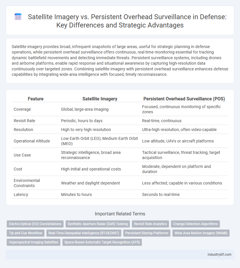
| Feature | Satellite Imagery | Persistent Overhead Surveillance (POS) |
|---|---|---|
| Coverage | Global, large-area imaging | Focused, continuous monitoring of specific zones |
| Revisit Rate | Periodic, hours to days | Real-time, continuous |
| Resolution | High to very high resolution | Ultra-high resolution, often video-capable |
| Operational Altitude | Low Earth Orbit (LEO), Medium Earth Orbit (MEO) | Low altitude, UAVs or aircraft platforms |
| Use Case | Strategic intelligence, broad area reconnaissance | Tactical surveillance, threat tracking, target acquisition |
| Cost | High initial and operational costs | Moderate, dependent on platform and duration |
| Environmental Constraints | Weather and daylight dependent | Less affected; capable in various conditions |
| Latency | Minutes to hours | Seconds to real-time |
Overview of Satellite Imagery and Persistent Overhead Surveillance
Satellite imagery offers high-resolution, wide-area visual data critical for strategic military reconnaissance, capable of capturing detailed geographical and structural information from orbit. Persistent overhead surveillance provides continuous, real-time monitoring of specific areas using airborne platforms such as drones or aircraft, enabling rapid response to dynamic battlefield conditions. Together, these technologies enhance situational awareness and intelligence gathering for defense operations by balancing broad coverage with constant observation.
Key Technological Differences
Satellite imagery offers high-resolution, wide-area coverage by capturing images from space-based platforms, enabling strategic intelligence gathering over large geographic regions. Persistent overhead surveillance employs airborne or space platforms with continuous monitoring capabilities, utilizing advanced sensors such as synthetic aperture radar and electro-optical/infrared to provide real-time, tactical intelligence. Key technological differences include revisit rates, where persistent surveillance provides near-continuous observation, while satellite imagery is constrained by orbital paths and weather conditions, affecting timely data acquisition.
Coverage Area and Temporal Resolution
Satellite imagery offers broad coverage areas, enabling large-scale monitoring of vast regions essential for strategic defense operations. Persistent overhead surveillance, utilizing drones or airborne systems, provides higher temporal resolution through continuous or frequent data collection, critical for real-time threat detection and rapid response. Optimizing defense capabilities requires balancing the extensive spatial reach of satellite imagery with the intensive temporal monitoring of persistent surveillance platforms.
Data Acquisition Speed and Frequency
Satellite imagery offers rapid data acquisition during specific orbital passes, providing high-resolution snapshots ideal for strategic reconnaissance, but with limited revisit frequency over a given target. Persistent overhead surveillance systems utilize airborne or space-based platforms that maintain continuous or near-real-time monitoring, enabling timely detection of dynamic activities and changes in operational areas. The trade-off involves Satellite imagery's higher spatial detail versus Persistent surveillance's enhanced temporal coverage, critical for adaptive threat assessment and mission responsiveness.
Imaging Capabilities: Resolution and Detail
Satellite imagery offers expansive coverage with spatial resolutions typically ranging from 30 centimeters to several meters, enabling detailed large-area reconnaissance. Persistent overhead surveillance systems provide continuous monitoring with higher revisit rates but often at lower spatial resolution, prioritizing temporal detail over fine imaging precision. The trade-off between high-resolution satellite imagery and frequent surveillance impacts tactical decision-making by balancing detailed target identification against real-time situational awareness.
Operational Flexibility and Tasking
Satellite imagery provides strategic intelligence with scheduled tasking but faces limitations in operational flexibility due to fixed orbits and revisit times. Persistent overhead surveillance offers continuous real-time monitoring, enabling dynamic tasking and rapid responsiveness to emerging threats. Military operations benefit from integrating both systems to balance high-resolution data acquisition with flexible, adaptive surveillance coverage.
Limitations and Vulnerabilities
Satellite imagery faces limitations such as fixed orbital paths causing intermittent coverage and susceptibility to weather conditions like cloud cover that obscure visuals. Persistent overhead surveillance offers continuous monitoring but is vulnerable to electronic jamming, signal interference, and high operational costs for sustained deployment. Both methods face challenges in real-time responsiveness and can be compromised by adversaries employing stealth technologies or counter-surveillance tactics.
Intelligence Applications in Defense Operations
Satellite imagery provides high-resolution, large-scale geospatial data critical for strategic intelligence and battlefield awareness, enabling the identification of enemy positions and infrastructure. Persistent overhead surveillance offers continuous real-time monitoring, enhancing tactical decision-making and rapid response capabilities by tracking movements and activities over extended periods. Combining both technologies optimizes intelligence applications, ensuring comprehensive situational awareness and improved defense operational effectiveness.
Cost, Accessibility, and Scalability
Satellite imagery offers extensive geographic coverage at a relatively lower cost compared to persistent overhead surveillance, which requires continuous operation and higher resource investment. Accessibility to satellite data is generally broader due to commercial providers and open-source platforms, whereas persistent surveillance systems often demand specialized technology and restricted access. Scalability favors satellite imagery, enabling rapid deployment over vast areas, while persistent systems are limited by infrastructure and operational constraints.
Future Trends and Integration in Defense Systems
Advancements in satellite imagery and persistent overhead surveillance are converging through AI-enhanced data analytics, enabling real-time, high-resolution intelligence for defense systems. Future trends indicate increased integration of multi-source sensor data, enhancing situational awareness and threat detection across diverse operational environments. Defense platforms are evolving to incorporate automated target recognition and secure, cloud-based information sharing, revolutionizing command and control capabilities.
Related Important Terms
Electro-Optical (EO) Constellations
Electro-Optical (EO) constellations in satellite imagery provide high-resolution, real-time data crucial for defense applications, enabling rapid identification and tracking of targets across large geographic areas. Persistent overhead surveillance combines multiple EO satellites to maintain continuous monitoring, enhancing situational awareness and threat detection capabilities beyond intermittent single-satellite imaging.
Synthetic Aperture Radar (SAR) Tasking
Satellite imagery leveraging Synthetic Aperture Radar (SAR) tasking provides high-resolution, all-weather, day-and-night reconnaissance crucial for defense operations, overcoming limitations of optical sensors in obscured environments. Persistent overhead surveillance enhances strategic situational awareness, but SAR tasking delivers precision targeting and dynamic area monitoring essential for rapid threat detection and battlefield decision-making.
Revisit Rate Analytics
Satellite imagery offers intermittent coverage limited by orbital patterns, resulting in lower revisit rates compared to Persistent Overhead Surveillance (POS), which provides continuous real-time monitoring critical for timely threat detection and dynamic battlefield assessment. Advanced revisit rate analytics in POS systems enable rapid identification of changes in target areas, enhancing situational awareness and operational decision-making with near-immediate data updates.
Change Detection Algorithms
Change detection algorithms in satellite imagery enable precise identification of terrain alterations and troop movements by analyzing temporal image sequences, enhancing strategic decision-making in defense operations. Persistent overhead surveillance continuously captures real-time data but relies on change detection algorithms to filter relevant anomalies from vast datasets, optimizing threat assessment and battlefield awareness.
Tip and Cue Workflow
Satellite imagery provides high-resolution snapshots critical for initial target identification, while Persistent Overhead Surveillance (POS) enables continuous monitoring that enhances the Tip and Cue Workflow by supplying real-time alerts and dynamic tracking. Integrating satellite data with POS improves situational awareness and accelerates decision-making in defense operations by efficiently cueing resources to emerging threats.
Real-Time Geospatial Intelligence (RT-GEOINT)
Satellite imagery provides high-resolution, periodic snapshots critical for strategic targeting, while Persistent Overhead Surveillance (POS) delivers continuous monitoring to capture transient activities and patterns. Real-Time Geospatial Intelligence (RT-GEOINT) integrates both data streams, enabling immediate actionable insights for battlefield awareness and dynamic decision-making.
Persistent Staring Platforms
Persistent staring platforms enable continuous, long-duration monitoring of specific areas, providing real-time intelligence critical for defense operations. Unlike traditional satellite imagery with scheduled revisit times, these platforms offer uninterrupted data streams that enhance target tracking, threat assessment, and situational awareness.
Wide Area Motion Imagery (WAMI)
Wide Area Motion Imagery (WAMI) offers continuous, real-time surveillance over expansive areas, capturing detailed motion patterns critical for defense operations, unlike satellite imagery which provides periodic snapshots limited by orbital paths and weather conditions. WAMI's persistent overhead surveillance enhances situational awareness by enabling continuous tracking of moving targets, improving tactical decision-making and threat detection across diverse terrains.
Hyperspectral Imaging Satellites
Hyperspectral imaging satellites deliver advanced defense capabilities by capturing detailed spectral data across numerous bands, enabling precise identification of materials and objects on the ground compared to traditional persistent overhead surveillance. These satellites enhance situational awareness and threat detection through high-resolution spectral signatures, improving intelligence, surveillance, and reconnaissance (ISR) operations.
Space-Based Automatic Target Recognition (ATR)
Space-Based Automatic Target Recognition (ATR) enhances defense capabilities by leveraging satellite imagery with advanced algorithms to identify and track targets in real-time, surpassing traditional persistent overhead surveillance in accuracy and responsiveness. This technology integrates high-resolution sensors and AI-driven analytics to provide continuous, automated threat detection essential for modern military operations.
Satellite imagery vs Persistent overhead surveillance Infographic