Geology studies the Earth's physical structure, materials, and processes, analyzing rocks, minerals, and tectonic activities to understand the planet's history and composition. Geoinformatics integrates geological data with advanced technologies like GIS, remote sensing, and spatial analysis to map, model, and manage Earth's resources more efficiently. While geology provides foundational knowledge of Earth sciences, geoinformatics enhances decision-making through digital tools that optimize data interpretation and visualization.
Table of Comparison
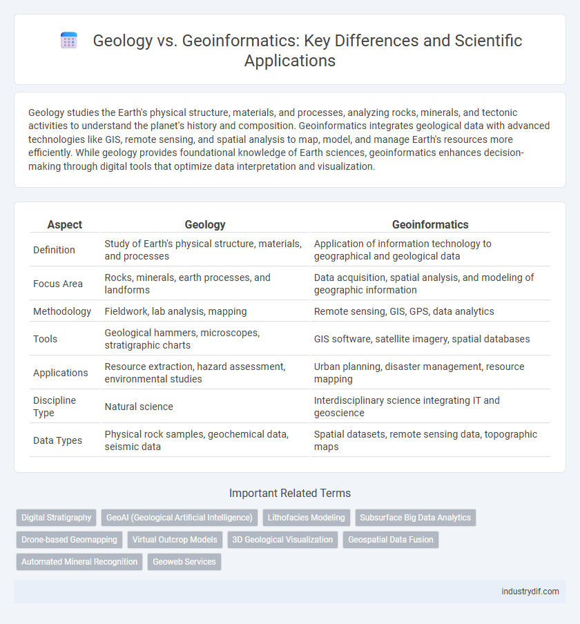
| Aspect | Geology | Geoinformatics |
|---|---|---|
| Definition | Study of Earth's physical structure, materials, and processes | Application of information technology to geographical and geological data |
| Focus Area | Rocks, minerals, earth processes, and landforms | Data acquisition, spatial analysis, and modeling of geographic information |
| Methodology | Fieldwork, lab analysis, mapping | Remote sensing, GIS, GPS, data analytics |
| Tools | Geological hammers, microscopes, stratigraphic charts | GIS software, satellite imagery, spatial databases |
| Applications | Resource extraction, hazard assessment, environmental studies | Urban planning, disaster management, resource mapping |
| Discipline Type | Natural science | Interdisciplinary science integrating IT and geoscience |
| Data Types | Physical rock samples, geochemical data, seismic data | Spatial datasets, remote sensing data, topographic maps |
Introduction to Geology and Geoinformatics
Geology studies Earth's physical structure, materials like rocks and minerals, and processes such as volcanic activity and plate tectonics shaping the planet over time. Geoinformatics integrates geospatial data acquisition, analysis, and visualization using technologies like GIS, remote sensing, and GPS to understand geological phenomena. These disciplines complement each other by combining field observations with spatial data modeling to analyze Earth's systems effectively.
Core Principles of Geology
Core principles of geology include the study of Earth's materials, structures, processes, and history, emphasizing rock formation, plate tectonics, stratigraphy, and mineralogy. These principles provide a fundamental understanding of Earth's physical characteristics and dynamic changes over geological time. Geology relies on field observations, fossil records, and geochronology to interpret Earth's past and predict future geological events.
Core Principles of Geoinformatics
Geoinformatics integrates spatial data acquisition, analysis, and visualization using advanced technologies such as GIS, remote sensing, and GPS to solve geological problems. Its core principles emphasize the management of geospatial data, spatial modeling, and decision-making support systems that enhance the understanding of Earth's processes. Unlike traditional geology, which focuses mainly on field observations and physical properties of rocks, geoinformatics leverages computational tools to analyze complex spatial relationships and patterns in the Earth's surface.
Key Differences between Geology and Geoinformatics
Geology primarily studies Earth's physical structure, materials, processes, and history through fieldwork and sample analysis, emphasizing rock formations, minerals, and tectonic activities. Geoinformatics integrates geographic information systems (GIS), remote sensing, and data science to collect, analyze, and visualize spatial data related to Earth's surface and environmental phenomena. The key difference lies in Geology's focus on understanding Earth's physical properties and processes, whereas Geoinformatics centers on applying computational tools for spatial data management and environmental monitoring.
Interdisciplinary Connections in Earth Sciences
Geology and geoinformatics intersect through the integration of traditional earth science methods with advanced computational tools to analyze spatial and temporal data. Geology provides the foundational understanding of Earth's physical structure and processes, while geoinformatics employs geographic information systems (GIS), remote sensing, and spatial analysis to enhance geological research accuracy and visualization. This interdisciplinary approach accelerates resource exploration, natural hazard assessment, and environmental monitoring by combining empirical geological data with cutting-edge geospatial technologies.
Essential Tools and Technologies in Geology
Essential tools in geology include rock hammers, hand lenses, GPS devices, and field notebooks, which enable precise data collection and analysis of geological formations. Technologies such as seismic imaging, remote sensing, and geochemical analysis facilitate the study of earth processes and mineral compositions. These instruments and techniques provide critical insights into earth structure, tectonic activity, and resource exploration.
Geoinformatics: Software and Data Applications
Geoinformatics leverages advanced software systems such as Geographic Information Systems (GIS), Remote Sensing (RS), and Global Positioning Systems (GPS) to collect, analyze, and visualize spatial data, enabling precise geological mapping and resource management. These tools facilitate the integration of multi-source datasets, enhancing the accuracy of geospatial models used in hazard assessment, mineral exploration, and environmental monitoring. The application of machine learning algorithms within geoinformatics significantly improves predictive analytics and decision-making capabilities in modern geological studies.
Career Opportunities in Geology vs Geoinformatics
Career opportunities in Geology predominantly include field research, mineral exploration, environmental consulting, and natural hazard assessment, emphasizing hands-on analysis of Earth's physical materials. Geoinformatics careers focus on spatial data analysis, geographic information systems (GIS), remote sensing, and environmental modeling, leveraging advanced computational tools to interpret geological information. Both fields offer roles in academia, government agencies, and private sectors, but Geoinformatics emphasizes technology-driven problem solving, creating demand for skills in programming and data science alongside geoscientific knowledge.
Real-world Applications and Case Studies
Geology examines Earth's physical structure and processes, aiding mineral exploration, earthquake risk assessment, and environmental management through field studies and laboratory analysis. Geoinformatics integrates geographic information systems (GIS), remote sensing, and spatial data analysis, optimizing land-use planning, disaster response, and natural resource management. Case studies demonstrate geology's role in resource identification while geoinformatics enhances data visualization and predictive modeling for informed decision-making.
Future Trends in Geology and Geoinformatics
Future trends in geology emphasize the integration of advanced remote sensing technologies and AI-driven data analysis to improve mineral exploration and natural hazard prediction. Geoinformatics continues to evolve with the development of machine learning algorithms and cloud-based GIS platforms, enabling real-time environmental monitoring and enhanced spatial data visualization. Both fields converge in utilizing big data analytics for sustainable resource management and climate change impact assessment.
Related Important Terms
Digital Stratigraphy
Digital stratigraphy leverages geoinformatics tools such as GIS, remote sensing, and 3D modeling to analyze and visualize sedimentary layers with enhanced accuracy compared to traditional geology methods. This integration facilitates precise correlation, data management, and interpretation of stratigraphic sequences essential for resource exploration and environmental studies.
GeoAI (Geological Artificial Intelligence)
GeoAI leverages machine learning algorithms and big data analytics to enhance geological modeling, mineral exploration, and seismic risk assessment, significantly improving accuracy and efficiency compared to traditional geological methods. Integrating remote sensing data and spatial analysis, GeoAI transforms geoinformatics by enabling predictive insights and automated interpretation of complex subsurface structures.
Lithofacies Modeling
Lithofacies modeling in geology involves the detailed analysis of rock formations to interpret depositional environments, while geoinformatics leverages spatial data technologies such as GIS and remote sensing to enhance the accuracy and efficiency of these models. Integration of geoinformatics tools with geological data enables more precise characterization of lithofacies distributions, critical for resource exploration and environmental assessment.
Subsurface Big Data Analytics
Subsurface Big Data Analytics in geology involves integrating and interpreting complex geological datasets to model earth formations, while geoinformatics enhances this process using advanced computational techniques, spatial data science, and machine learning algorithms for precise subsurface mapping. The fusion of geoinformatics tools with geological expertise enables efficient handling of massive datasets, improving reservoir characterization, mineral exploration, and seismic risk assessment.
Drone-based Geomapping
Drone-based geomapping revolutionizes traditional geology by integrating high-resolution aerial data with geoinformatics techniques, enabling precise terrain analysis and mineral exploration. Advanced GIS algorithms process multispectral drone imagery to generate accurate 3D geological models, enhancing resource management and environmental monitoring.
Virtual Outcrop Models
Virtual Outcrop Models (VOMs) in Geology provide detailed 3D representations of rock formations, enabling precise stratigraphic analysis and structural interpretation. Geoinformatics leverages advanced spatial data processing and machine learning algorithms to enhance VOM accuracy, facilitating automated feature extraction and improved subsurface modeling.
3D Geological Visualization
3D geological visualization in geology involves interpreting subsurface structures through traditional methods like field mapping and core sampling, enabling accurate representation of rock formations and fault lines. Geoinformatics enhances this process by integrating advanced GIS, remote sensing, and spatial data analysis techniques to create dynamic, interactive 3D models that improve predictive accuracy and resource management.
Geospatial Data Fusion
Geology primarily studies Earth's physical structure, mineral composition, and processes through field observations and laboratory analysis, while Geoinformatics leverages computational techniques to manage and analyze spatial data. Geospatial data fusion in Geoinformatics integrates multisource geospatial datasets to enhance accuracy, enable complex terrain modeling, and support advanced geological interpretation and decision-making.
Automated Mineral Recognition
Automated mineral recognition leverages geoinformatics technologies such as machine learning algorithms and hyperspectral imaging to analyze geological samples with higher precision and speed than traditional geology methods. Integrating geospatial data and computational models enhances mineral identification accuracy, revolutionizing exploration and resource management in geoscience.
Geoweb Services
Geology studies Earth's physical structure and processes, while geoinformatics integrates GIS, remote sensing, and geospatial data analysis to enhance geological research through Geoweb services. Geoweb services enable real-time access, visualization, and sharing of geospatial data, supporting dynamic geological mapping and environmental monitoring.
Geology vs Geoinformatics Infographic