Route optimization enhances transportation efficiency by calculating the most effective paths for vehicles, reducing travel time and fuel consumption. Geofencing creates virtual boundaries that trigger notifications when vehicles enter or exit specific zones, improving monitoring and security. Combining both technologies streamlines fleet management, ensuring timely deliveries and precise location tracking.
Table of Comparison
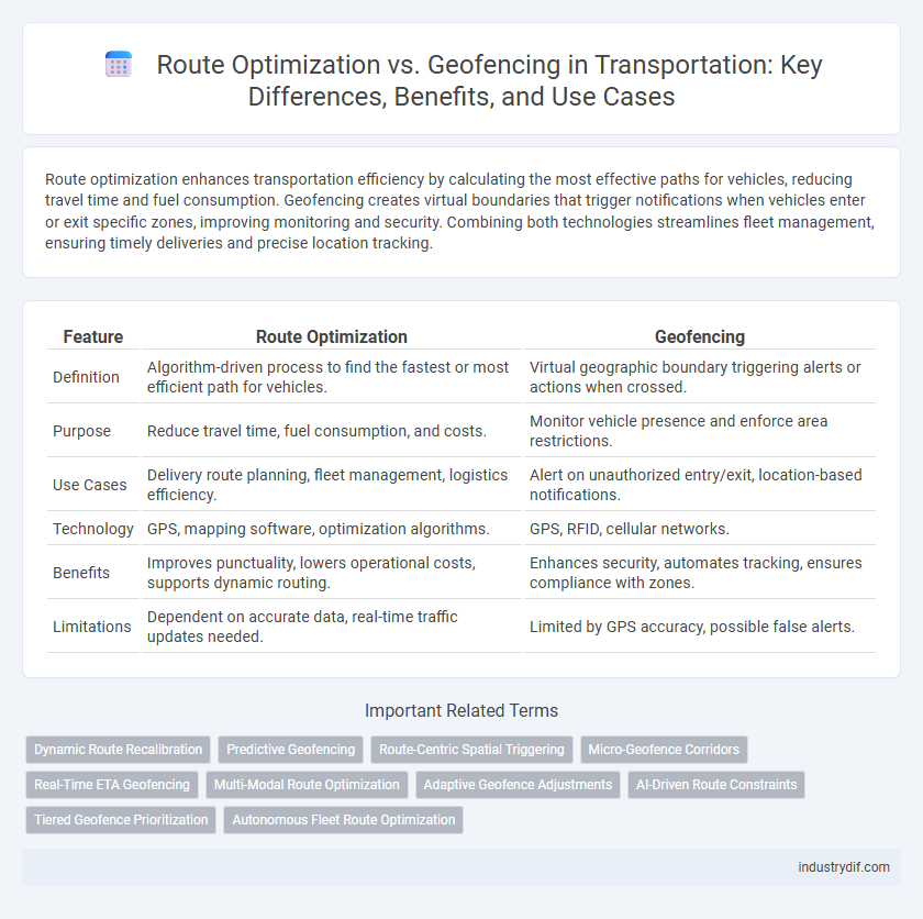
| Feature | Route Optimization | Geofencing |
|---|---|---|
| Definition | Algorithm-driven process to find the fastest or most efficient path for vehicles. | Virtual geographic boundary triggering alerts or actions when crossed. |
| Purpose | Reduce travel time, fuel consumption, and costs. | Monitor vehicle presence and enforce area restrictions. |
| Use Cases | Delivery route planning, fleet management, logistics efficiency. | Alert on unauthorized entry/exit, location-based notifications. |
| Technology | GPS, mapping software, optimization algorithms. | GPS, RFID, cellular networks. |
| Benefits | Improves punctuality, lowers operational costs, supports dynamic routing. | Enhances security, automates tracking, ensures compliance with zones. |
| Limitations | Dependent on accurate data, real-time traffic updates needed. | Limited by GPS accuracy, possible false alerts. |
Understanding Route Optimization in Transportation
Route optimization in transportation involves using advanced algorithms and real-time data to determine the most efficient paths for vehicles, minimizing fuel consumption and delivery times. This process considers traffic patterns, delivery windows, vehicle capacities, and road restrictions to enhance operational efficiency and reduce costs. Effective route optimization directly improves customer satisfaction by ensuring timely deliveries and better resource utilization.
What is Geofencing and How It Works
Geofencing is a location-based technology that creates virtual boundaries around specific geographic areas using GPS or RFID. When a vehicle or asset enters or exits these predefined zones, triggered alerts or actions are automatically executed, enabling real-time monitoring and efficient management. This precise control helps optimize routes by enforcing geographic restrictions, improving safety, and enhancing operational efficiency in transportation logistics.
Key Differences: Route Optimization vs Geofencing
Route optimization focuses on calculating the most efficient paths for vehicles, reducing travel time, fuel consumption, and operational costs by analyzing factors such as traffic, distance, and delivery windows. Geofencing involves creating virtual boundaries around specific geographic areas, triggering alerts or actions when vehicles enter or exit these predefined zones, enhancing security, compliance, and real-time monitoring. The key difference lies in route optimization's emphasis on planning and efficiency, while geofencing centers on location-based tracking and event management.
Benefits of Implementing Route Optimization
Implementing route optimization in transportation significantly reduces fuel consumption and operational costs by calculating the most efficient paths for vehicles, which enhances delivery speed and reliability. It improves fleet productivity by minimizing idle time and avoiding traffic congestion through real-time data analysis and dynamic rerouting. These benefits contribute to lower carbon emissions and increased customer satisfaction, driving sustainable and efficient logistics management.
Advantages of Geofencing for Fleet Management
Geofencing enhances fleet management by providing real-time location monitoring, enabling immediate alerts when vehicles enter or exit predefined zones, which improves security and operational control. This technology reduces unauthorized usage and helps optimize route adherence without extensive manual oversight. Integrating geofencing with GPS tracking systems boosts efficiency by automating compliance checks and supporting timely decision-making in transportation logistics.
Integration of Route Optimization and Geofencing
Integrating route optimization with geofencing enhances fleet management by automatically adjusting routes based on predefined geographic boundaries, improving delivery efficiency and reducing operational costs. Real-time geofence alerts combined with dynamic route recalculations ensure compliance with zone restrictions and optimize travel times. This integration leverages GPS data and advanced algorithms to streamline navigation while maintaining regulatory and safety standards within designated areas.
Use Cases: Route Optimization in Logistics
Route optimization in logistics enhances delivery efficiency by calculating the most effective paths based on real-time traffic, fuel consumption, and vehicle capacity constraints. Fleet managers utilize route optimization software to reduce operational costs and improve customer satisfaction through timely shipments and minimized idle times. This technology supports last-mile delivery, distribution planning, and dynamic rerouting during unexpected delays or road closures.
Use Cases: Geofencing in Transportation
Geofencing in transportation is widely used for real-time vehicle tracking, automated alerts for entry or exit from designated zones, and improving logistics efficiency by monitoring fleet movements. This technology enhances safety by triggering notifications when a vehicle deviates from its planned route or enters restricted areas. Companies leverage geofencing to streamline delivery operations, optimize driver behavior, and ensure compliance with regulatory boundaries.
Challenges in Adopting Route Optimization and Geofencing
Implementing route optimization faces challenges such as inaccurate GPS data and dynamic traffic conditions that complicate real-time adjustments, leading to suboptimal routing decisions. Geofencing adoption struggles with technological limitations like inconsistent mobile signal coverage and privacy concerns regarding location tracking. Both technologies require significant integration efforts with existing fleet management systems, posing hurdles in data synchronization and operational workflow alignment.
Future Trends: Route Optimization and Geofencing Technologies
Future trends in transportation emphasize the integration of advanced route optimization algorithms with dynamic geofencing technologies to enhance real-time fleet management and reduce operational costs. Machine learning models improve route efficiency by analyzing traffic patterns, while geofencing enables automated location-based alerts and compliance monitoring. Emerging innovations include AI-driven predictive routing and adaptive geofences that respond to environmental changes, driving smarter logistics and safer transportation networks.
Related Important Terms
Dynamic Route Recalibration
Dynamic route recalibration leverages real-time traffic data and geofencing technology to continuously adjust delivery paths, minimizing fuel consumption and improving on-time performance. This integration enhances route optimization by dynamically rerouting vehicles around traffic congestion, accidents, or restricted zones, ensuring efficient and compliant transportation operations.
Predictive Geofencing
Route optimization improves transportation efficiency by calculating the most effective paths based on real-time traffic data and delivery schedules. Predictive geofencing enhances this by anticipating vehicle locations and triggering actions before entering predefined zones, enabling proactive route adjustments and improved fleet management.
Route-Centric Spatial Triggering
Route-centric spatial triggering enhances transportation efficiency by activating alerts and actions based on a vehicle's precise position along a predefined route, surpassing traditional geofencing that relies on fixed area boundaries. This dynamic approach optimizes delivery schedules, reduces fuel consumption, and improves real-time decision-making by integrating GPS data with route-specific parameters.
Micro-Geofence Corridors
Micro-geofence corridors enhance route optimization by creating precise, narrow zones that guide vehicles along designated paths, improving traffic flow and reducing delays. Integrating micro-geofences with real-time GPS data enables dynamic adjustments to routes, minimizing fuel consumption and increasing delivery efficiency.
Real-Time ETA Geofencing
Real-time ETA geofencing enhances route optimization by dynamically adjusting routes based on precise arrival times, ensuring efficient vehicle dispatch and minimizing delays. Integrating real-time GPS tracking with geofencing zones allows transportation managers to monitor arrivals and departures instantly, improving operational accuracy and customer satisfaction.
Multi-Modal Route Optimization
Multi-modal route optimization integrates various transportation modes such as buses, trains, and rideshares to minimize travel time and costs by analyzing real-time data and traffic conditions. Geofencing enhances this process by creating virtual boundaries that trigger alerts for route deviations, ensuring efficient fleet management and adherence to designated transport corridors.
Adaptive Geofence Adjustments
Adaptive geofence adjustments enhance route optimization by dynamically modifying geographic boundaries based on real-time traffic patterns, vehicle locations, and delivery priorities to improve operational efficiency. Integrating adaptive geofencing with advanced route planning algorithms minimizes delays, reduces fuel consumption, and ensures timely arrivals within optimized service zones.
AI-Driven Route Constraints
AI-driven route constraints enhance route optimization by dynamically adjusting paths based on real-time geofencing data, traffic patterns, and vehicle capabilities to improve efficiency and compliance. Integrating geofencing with AI enables precise boundary enforcement while optimizing routes for fuel consumption, delivery times, and regulatory requirements in transportation management.
Tiered Geofence Prioritization
Tiered geofence prioritization enhances route optimization by assigning varying levels of importance to geofences, ensuring that critical zones like delivery points or high-traffic areas receive prioritized routing decisions. This hierarchical approach improves efficiency in transportation logistics by dynamically adjusting routes based on the most relevant geofence triggers, reducing delays and operational costs.
Autonomous Fleet Route Optimization
Autonomous fleet route optimization leverages advanced algorithms and real-time data to reduce travel time, fuel consumption, and operational costs by identifying the most efficient paths for self-driving vehicles. Geofencing enhances this process by creating virtual boundaries that trigger specific actions or restrictions, ensuring compliance with regulatory zones and improving route safety within designated areas.
Route Optimization vs Geofencing Infographic