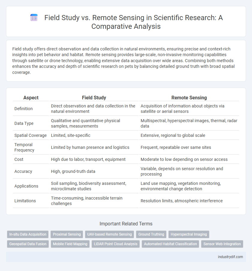
Field study offers direct observation and data collection in natural environments, ensuring precise and context-rich insights into pet behavior and habitat. Remote sensing provides large-scale, non-invasive monitoring capabilities through satellite or drone technology, enabling extensive data acquisition over wide areas. Combining both methods enhances the accuracy and depth of scientific research on pets by balancing detailed ground truth with broad spatial coverage.
Table of Comparison
| Aspect | Field Study | Remote Sensing |
|---|---|---|
| Definition | Direct observation and data collection in the natural environment | Acquisition of information about objects via satellite or aerial sensors |
| Data Type | Qualitative and quantitative physical samples, measurements | Multispectral, hyperspectral images, thermal, radar data |
| Spatial Coverage | Limited, site-specific | Extensive, regional to global scale |
| Temporal Frequency | Limited by human presence and logistics | Frequent, repeatable over same sites |
| Cost | High due to labor, transport, equipment | Moderate to low depending on sensor access |
| Accuracy | High, ground-truth data | Variable, depends on sensor resolution and processing |
| Applications | Soil sampling, biodiversity assessment, microclimate studies | Land use mapping, vegetation monitoring, environmental change detection |
| Limitations | Time-consuming, inaccessible terrain challenges | Resolution limits, atmospheric interference |
Definition of Field Study in Scientific Research
Field study in scientific research refers to the systematic collection of data directly from natural environments through observation, experimentation, or sampling. It involves in-situ measurements that provide detailed, context-rich information critical for validating remote sensing data and understanding complex ecological or geological phenomena. This hands-on approach enables researchers to capture localized variations and interactions that remote sensing methods may not fully detect.
Overview of Remote Sensing Technologies
Remote sensing technologies utilize satellite and aerial sensors to collect data on Earth's surface, enabling large-scale environmental monitoring with high spatial and temporal resolution. These technologies employ various spectral bands, including visible, infrared, and microwave, to detect vegetation health, land use changes, and atmospheric conditions. Advanced platforms like LiDAR and hyperspectral imaging provide detailed three-dimensional mapping and precise material identification beyond the capabilities of traditional field studies.
Methodological Differences: Field Study vs Remote Sensing
Field studies involve direct, on-site data collection through observations, measurements, and sample analysis, providing high-resolution and context-specific information. Remote sensing utilizes satellite or aerial imagery to gather large-scale environmental data, enabling analysis over extensive areas with lower spatial resolution. The methodological differences center on data granularity, cost, temporal frequency, and the balance between detailed local insights versus broad spatial coverage.
Data Collection Techniques in Field Work
Field study data collection techniques involve direct observation, manual sampling, and in-situ measurements, which provide high-resolution, site-specific information essential for ground-truthing remote sensing data. Remote sensing utilizes satellite imagery, aerial photography, and drone-based sensors to gather large-scale environmental data efficiently across extensive and inaccessible areas. Integrating field work with remote sensing enhances accuracy by validating and calibrating spatial data with empirical measurements.
Remote Sensing Data Acquisition and Processing
Remote sensing data acquisition relies on satellite or aerial sensors to capture high-resolution images and spectral information over large geographic areas, enabling efficient monitoring of environmental changes and land use. Processing techniques such as radiometric correction, atmospheric correction, and image classification enhance data accuracy and interpretability for applications in agriculture, forestry, and urban planning. Advanced algorithms, including machine learning and deep learning, facilitate automated feature extraction and change detection, improving the precision and scalability of remote sensing analysis compared to traditional field studies.
Accuracy and Reliability: Comparing Results
Field study methods typically provide high accuracy and reliability by enabling direct sample collection and in situ measurements, offering precise ground-truth data. Remote sensing delivers extensive spatial coverage and frequent monitoring but may suffer from variability in sensor calibration and atmospheric interference, affecting data accuracy. Comparing both approaches reveals field studies excel in detailed local validation, while remote sensing ensures broader-area consistency and trend reliability.
Applications in Environmental Science
Field study provides precise, ground-truth data critical for validating remote sensing observations and assessing ecosystem health, biodiversity, and soil characteristics. Remote sensing offers large-scale, continuous monitoring capabilities for tracking deforestation, land-use changes, and climate impacts on environments over time. Integrating both methods enhances accuracy in environmental modeling, natural resource management, and disaster response planning.
Cost and Resource Implications
Field studies require significant investment in personnel, equipment, and time for on-site data collection, resulting in higher operational costs compared to remote sensing. Remote sensing leverages satellite or aerial imagery, reducing the need for extensive fieldwork and enabling cost-effective monitoring over large or inaccessible areas. The scalability and frequency of data acquisition in remote sensing offer substantial resource savings, although initial setup and data processing infrastructure may require considerable funding.
Limitations and Challenges of Each Approach
Field study offers high-resolution, ground-truth data essential for validating ecological models but is limited by spatial coverage, labor intensity, and temporal constraints. Remote sensing provides extensive spatial and temporal data sets useful for monitoring large-scale environmental changes, yet accuracy can be compromised by atmospheric interference, sensor resolution limits, and difficulties in interpreting heterogeneous landscapes. Integrating both methods can mitigate individual shortcomings by combining precise, localized measurements with broad, continuous observations.
Future Trends in Integrated Field Study and Remote Sensing
Future trends in integrated field study and remote sensing emphasize the fusion of high-resolution satellite imagery with in-situ sensor data to enhance environmental monitoring accuracy. Advances in machine learning algorithms enable real-time data processing and predictive modeling, facilitating precise ecosystem assessments and climate change impact analysis. Emerging technologies like drone-based hyperspectral imaging combined with ground truthing improve spatial-temporal resolution and provide comprehensive validation for remote observations.
Related Important Terms
In-situ Data Acquisition
In-situ data acquisition involves direct measurements collected on-site using instruments such as soil sensors, weather stations, or water quality probes, providing high accuracy and ground-truth validation for environmental parameters. Unlike remote sensing, which relies on satellite or aerial imagery, field studies enable detailed, localized monitoring essential for calibrating and verifying remotely sensed data.
Proximal Sensing
Proximal sensing, a subset of remote sensing conducted near the target object, offers higher spatial resolution and accuracy than traditional field studies, enabling detailed data collection in precision agriculture and environmental monitoring. Unlike broad-scale remote sensing platforms like satellites, proximal sensors such as handheld spectrometers or UAV-mounted devices allow for real-time, site-specific analysis, enhancing the precision of ecological and agronomic assessments.
UAV-based Remote Sensing
UAV-based remote sensing offers high-resolution, real-time data acquisition over large and inaccessible areas, enabling precise monitoring of environmental parameters compared to traditional field studies. Integrating multispectral and LiDAR sensors on UAVs enhances vegetation analysis and topographic mapping, significantly reducing time and labor costs while improving spatial accuracy.
Ground Truthing
Ground truthing involves verifying remote sensing data through direct field observations to ensure accuracy in environmental monitoring and land-use classification. This method enhances remote sensing analysis by providing precise, on-the-ground measurements that calibrate and validate satellite or aerial imagery interpretations.
Hyperspectral Imaging
Field study provides ground-truth data essential for calibrating hyperspectral imaging models, ensuring accurate spectral signatures of vegetation and minerals. Hyperspectral imaging in remote sensing enables large-scale environmental monitoring by capturing detailed spectral information across numerous contiguous bands, facilitating the detection of subtle biochemical and biophysical properties.
Geospatial Data Fusion
Field study provides high-accuracy, ground-truth geospatial data essential for validating remote sensing outputs, while remote sensing offers extensive spatial coverage and temporal frequency unattainable through in-situ measurements. Integrating these data sources through geospatial data fusion enhances environmental monitoring, improves land use classification, and supports precision agriculture by leveraging the complementary strengths of detailed field observations and broad-scale satellite imagery.
Mobile Field Mapping
Mobile field mapping enhances data accuracy and contextual understanding by enabling real-time GPS-based spatial data collection and in situ observations, which often surpass the resolution limits of remote sensing imagery. Integrating mobile field mapping with remote sensing allows scientists to validate satellite or aerial data, improve land cover classification, and monitor environmental changes with greater precision.
LiDAR Point Cloud Analysis
LiDAR point cloud analysis in remote sensing provides high-resolution, three-dimensional spatial data enabling precise topographic mapping and vegetation structure assessment over large areas, surpassing the spatial limitations of traditional field studies. Field studies, while offering detailed ground-truth validation and species-specific information, are often constrained by time, accessibility, and labor, making LiDAR-based remote sensing a more efficient tool for landscape-scale ecological and geological research.
Automated Habitat Classification
Automated habitat classification using remote sensing integrates high-resolution satellite imagery and machine learning algorithms to efficiently analyze extensive ecosystems, surpassing the spatial limitations of traditional field studies. Field study data remain crucial for ground-truthing remote sensing outputs, enhancing classification accuracy through direct species identification and environmental parameter measurements.
Sensor Web Integration
Field study offers precise, ground-truth data essential for calibrating remote sensing sensors, while sensor web integration enables real-time, multi-sensor data fusion for comprehensive environmental monitoring. Combining in situ measurements with satellite and drone-based remote sensing through sensor web architectures enhances spatial-temporal resolution and accuracy in ecological and climate research.
Field Study vs Remote Sensing Infographic