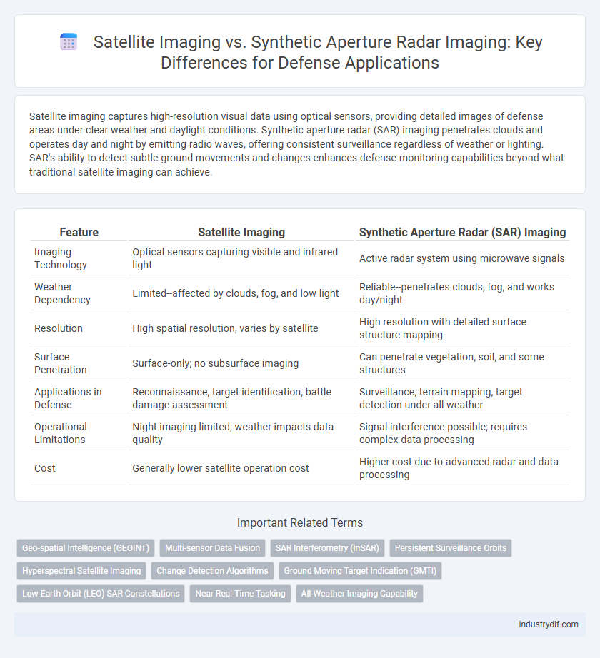
Satellite imaging captures high-resolution visual data using optical sensors, providing detailed images of defense areas under clear weather and daylight conditions. Synthetic aperture radar (SAR) imaging penetrates clouds and operates day and night by emitting radio waves, offering consistent surveillance regardless of weather or lighting. SAR's ability to detect subtle ground movements and changes enhances defense monitoring capabilities beyond what traditional satellite imaging can achieve.
Table of Comparison
| Feature | Satellite Imaging | Synthetic Aperture Radar (SAR) Imaging |
|---|---|---|
| Imaging Technology | Optical sensors capturing visible and infrared light | Active radar system using microwave signals |
| Weather Dependency | Limited--affected by clouds, fog, and low light | Reliable--penetrates clouds, fog, and works day/night |
| Resolution | High spatial resolution, varies by satellite | High resolution with detailed surface structure mapping |
| Surface Penetration | Surface-only; no subsurface imaging | Can penetrate vegetation, soil, and some structures |
| Applications in Defense | Reconnaissance, target identification, battle damage assessment | Surveillance, terrain mapping, target detection under all weather |
| Operational Limitations | Night imaging limited; weather impacts data quality | Signal interference possible; requires complex data processing |
| Cost | Generally lower satellite operation cost | Higher cost due to advanced radar and data processing |
Introduction to Satellite Imaging and Synthetic Aperture Radar (SAR)
Satellite imaging provides high-resolution optical images by capturing reflected sunlight, essential for real-time reconnaissance and terrain analysis in defense operations. Synthetic Aperture Radar (SAR) emits microwave signals to generate detailed images regardless of weather or lighting conditions, enabling continuous surveillance and target detection. Combining satellite imaging with SAR enhances situational awareness and strategic decision-making in complex defense scenarios.
Core Principles: Optical vs Radar Imaging
Satellite imaging relies on optical sensors that capture reflected sunlight to produce high-resolution images based on visible and infrared wavelengths, enabling detailed surface analysis during daylight and clear weather conditions. Synthetic aperture radar (SAR) imaging emits microwave signals and measures the backscatter, allowing it to penetrate clouds, smoke, and darkness, providing all-weather, day-and-night surveillance critical for military reconnaissance. The core difference lies in satellite optical imaging's dependence on ambient light versus SAR's active radar signal generation, making SAR essential for consistent intelligence gathering regardless of environmental factors.
Resolution and Image Quality Comparison
Satellite imaging offers high-resolution optical images with detailed visual clarity under clear weather conditions, capturing fine surface features essential for defense surveillance. Synthetic aperture radar (SAR) imaging provides consistent high-resolution imagery regardless of weather or lighting, penetrating clouds and darkness to detect surface changes and moving targets. Combining both techniques enhances situational awareness by leveraging satellite imaging's spatial resolution and SAR's all-weather, day-and-night imaging capabilities.
Weather and Day/Night Imaging Capabilities
Satellite imaging relies on optical sensors that are limited by cloud cover and lack of daylight, reducing effectiveness in adverse weather and nighttime operations. Synthetic aperture radar (SAR) imaging penetrates clouds and functions independently of light conditions, providing consistent, high-resolution imagery regardless of weather or time of day. These capabilities make SAR indispensable for continuous surveillance and reconnaissance in defense applications.
Data Acquisition Speed and Coverage
Satellite imaging typically offers high-resolution optical data with rapid data acquisition under clear weather conditions, while synthetic aperture radar (SAR) imaging excels in all-weather, day-and-night coverage with consistent spatial resolution. SAR's capability to penetrate clouds and its wide-area imaging allows for broader coverage and frequent revisits, crucial for time-sensitive defense surveillance. Data acquisition speed in SAR is enhanced by its active sensing technology, enabling real-time monitoring across diverse terrains unlike passive satellite optical sensors.
Applications in Military and Defense Operations
Satellite imaging provides high-resolution optical imagery essential for real-time reconnaissance, battlefield monitoring, and target identification in military operations. Synthetic aperture radar (SAR) offers all-weather, day-and-night surveillance capabilities, crucial for detecting concealed targets, troop movements, and terrain changes in diverse environments. Integrating SAR with optical satellite data enhances situational awareness, improves threat assessment accuracy, and supports strategic defense decision-making.
Advantages of Satellite Imaging in Defense
Satellite imaging offers high-resolution visual data critical for real-time surveillance and reconnaissance in defense operations, enabling precise target identification and battlefield assessment. It provides extensive coverage over large geographic areas, facilitating early warning and strategic planning. Unlike synthetic aperture radar, satellite imaging captures detailed optical imagery that aids in discriminating between different types of military assets and infrastructure.
Benefits of SAR Imaging for Surveillance and Reconnaissance
Synthetic Aperture Radar (SAR) imaging offers significant advantages for surveillance and reconnaissance, including the ability to capture high-resolution images regardless of weather conditions or time of day. Unlike traditional satellite imaging, SAR penetrates through clouds, fog, and vegetation, enabling consistent monitoring in diverse environments. The precise target detection and detailed terrain mapping capabilities of SAR enhance situational awareness and threat assessment in defense operations.
Limitations and Challenges of Each Technology
Satellite imaging faces limitations such as dependency on clear weather and daylight, which can hinder intelligence gathering during adverse conditions. Synthetic aperture radar (SAR) imaging overcomes visibility issues by using radio waves, but it struggles with lower resolution and complex data interpretation. Both technologies require advanced processing algorithms and considerable computational resources to maximize accuracy and operational effectiveness in defense surveillance.
Future Trends in Defense Imaging Technologies
Satellite imaging and synthetic aperture radar (SAR) imaging are evolving rapidly with advancements in resolution, real-time data processing, and multi-spectral capabilities tailored for defense applications. Emerging trends include the integration of AI-driven analytics for enhanced target identification and automated threat assessment, enabling more precise reconnaissance and surveillance. The fusion of satellite optical sensors with SAR's all-weather, day-and-night imaging is enhancing situational awareness, operational decision-making, and battlefield intelligence in future defense systems.
Related Important Terms
Geo-spatial Intelligence (GEOINT)
Satellite imaging provides high-resolution optical images critical for detailed terrain analysis and target identification in Geo-spatial Intelligence (GEOINT), while Synthetic Aperture Radar (SAR) imaging captures surface information through cloud cover and darkness, enabling continuous surveillance and reliable detection of objects and changes. The fusion of satellite optical data and SAR imagery enhances situational awareness, terrain mapping, and threat assessment in defense applications by leveraging complementary strengths in electromagnetic spectrum utilization.
Multi-sensor Data Fusion
Satellite imaging and synthetic aperture radar (SAR) imaging provide complementary data types essential for multi-sensor data fusion in defense applications, enhancing target detection, classification, and situational awareness in diverse environments. Integrating optical satellite data's high-resolution visual detail with SAR's all-weather, day-and-night imaging capability improves battlefield surveillance accuracy and resilience against camouflage or obscurants.
SAR Interferometry (InSAR)
Synthetic Aperture Radar (SAR) Interferometry (InSAR) provides critical advantages in defense by enabling precise ground deformation measurements and terrain mapping through phase difference analysis of multiple SAR images, unaffected by weather or lighting conditions. Unlike traditional satellite imaging that relies on optical sensors limited by cloud cover and daylight, InSAR delivers high-resolution, real-time geospatial intelligence essential for surveillance, reconnaissance, and battlefield situational awareness.
Persistent Surveillance Orbits
Satellite imaging using optical sensors provides high-resolution, multi-spectral data ideal for daytime persistent surveillance orbits, but is limited by weather and lighting conditions. Synthetic aperture radar (SAR) imaging offers reliable all-weather, day-and-night persistent surveillance capabilities by penetrating clouds and darkness, enhancing continuous monitoring of dynamic defense targets.
Hyperspectral Satellite Imaging
Hyperspectral satellite imaging captures a wide spectrum of light beyond visible wavelengths, enabling detailed material identification and precise threat detection in defense applications. Unlike synthetic aperture radar imaging, which excels in all-weather and day-night surveillance, hyperspectral imaging provides critical spectral signatures essential for identifying camouflaged objects and chemical compounds.
Change Detection Algorithms
Satellite imaging relies on optical sensors to capture high-resolution visuals, enabling precise change detection through spectral analysis in clear weather conditions. Synthetic aperture radar (SAR) imaging penetrates clouds and darkness, using electromagnetic wave reflections combined with advanced change detection algorithms like coherence analysis to identify ground alterations in all environments.
Ground Moving Target Indication (GMTI)
Satellite imaging provides high-resolution optical data for ground moving target indication (GMTI) but is limited by weather and daylight conditions. Synthetic aperture radar (SAR) imaging offers all-weather, day-and-night GMTI capabilities with enhanced detection of moving targets through Doppler shift analysis, crucial for persistent surveillance in defense applications.
Low-Earth Orbit (LEO) SAR Constellations
Low-Earth Orbit (LEO) SAR constellations provide unparalleled all-weather, day-and-night surveillance capabilities, outperforming traditional satellite imaging systems which rely on optical sensors limited by weather and lighting conditions. These SAR constellations enable real-time, high-resolution terrain mapping and target detection crucial for defense intelligence, reconnaissance, and battlefield awareness.
Near Real-Time Tasking
Satellite imaging provides high-resolution optical images for defense reconnaissance but is limited by weather conditions and daylight availability; synthetic aperture radar (SAR) imaging delivers all-weather, day-and-night near real-time tasking capabilities with precise surface change detection and target identification. SAR's ability to penetrate clouds and operate in darkness makes it indispensable for timely situational awareness and rapid response in dynamic defense operations.
All-Weather Imaging Capability
Satellite imaging relies on optical sensors that are limited by cloud cover, fog, and darkness, reducing effectiveness in adverse weather conditions. Synthetic aperture radar (SAR) imaging operates using microwave signals that penetrate clouds and function independently of lighting, providing reliable all-weather, day-and-night reconnaissance for defense operations.
Satellite imaging vs Synthetic aperture radar imaging Infographic