Fieldwork provides hands-on data collection and direct observation critical for accurate ecological studies in scientific pet research. Remote sensing offers large-scale environmental monitoring and temporal analysis through advanced satellite imagery and aerial surveys. Combining both methods enhances data accuracy and breadth, facilitating comprehensive insights into pet habitats and behaviors.
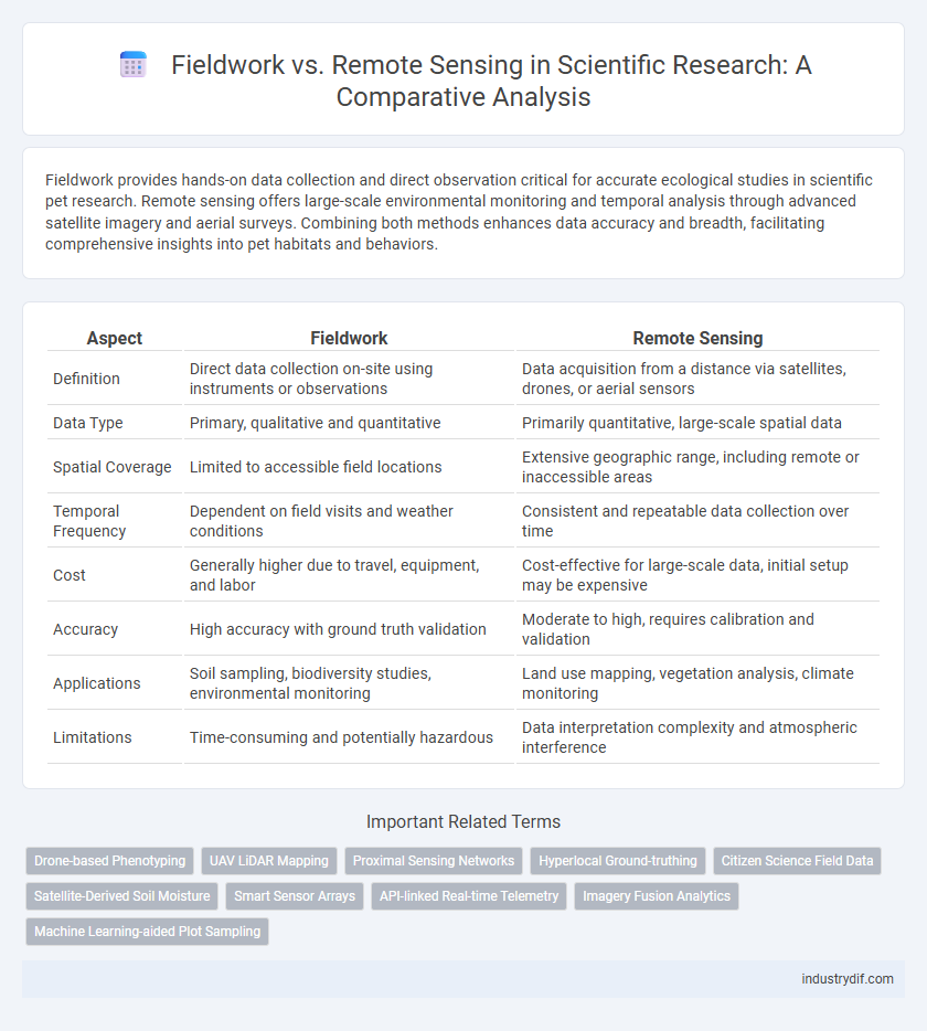
Table of Comparison
| Aspect | Fieldwork | Remote Sensing |
|---|---|---|
| Definition | Direct data collection on-site using instruments or observations | Data acquisition from a distance via satellites, drones, or aerial sensors |
| Data Type | Primary, qualitative and quantitative | Primarily quantitative, large-scale spatial data |
| Spatial Coverage | Limited to accessible field locations | Extensive geographic range, including remote or inaccessible areas |
| Temporal Frequency | Dependent on field visits and weather conditions | Consistent and repeatable data collection over time |
| Cost | Generally higher due to travel, equipment, and labor | Cost-effective for large-scale data, initial setup may be expensive |
| Accuracy | High accuracy with ground truth validation | Moderate to high, requires calibration and validation |
| Applications | Soil sampling, biodiversity studies, environmental monitoring | Land use mapping, vegetation analysis, climate monitoring |
| Limitations | Time-consuming and potentially hazardous | Data interpretation complexity and atmospheric interference |
Introduction to Fieldwork and Remote Sensing
Fieldwork involves direct data collection through on-site observation and sampling, providing precise, ground-truth information essential for validating remote sensing data. Remote sensing employs satellite or aerial imagery to gather large-scale environmental and geospatial data, enabling efficient monitoring of inaccessible or expansive areas. Combining fieldwork with remote sensing enhances data accuracy and spatial analysis for scientific research in disciplines such as ecology, geology, and environmental science.
Core Definitions: Fieldwork vs Remote Sensing
Fieldwork involves direct, on-site data collection through observation, sampling, and measurement to gather empirical evidence in natural environments. Remote sensing utilizes satellite or aerial sensor technologies to acquire spatial information and monitor Earth's surface without physical contact. Both methods provide complementary datasets crucial for comprehensive environmental and geological analysis.
Historical Development of Data Collection Methods
Fieldwork data collection dates back to early scientific explorations, relying on direct observation and manual measurements for accurate environmental and archaeological insights. Remote sensing emerged in the mid-20th century with advancements in aerial photography, satellite imagery, and radar technologies, revolutionizing large-scale data acquisition. The integration of Geographic Information Systems (GIS) further enhanced data analysis, enabling complex spatial and temporal studies across diverse scientific disciplines.
Key Technologies in Fieldwork and Remote Sensing
Fieldwork relies heavily on GPS devices, portable spectrometers, and UAVs (drones) to collect precise geospatial data and environmental samples directly from the study site. Remote sensing utilizes satellite imagery, LiDAR, and multispectral sensors to gather extensive data over large areas, enabling analysis of land cover, vegetation health, and climate variables. Both technologies integrate GIS software to process and visualize spatial information, enhancing accuracy and decision-making in scientific research.
Data Accuracy and Validation Techniques
Fieldwork provides direct data collection with high spatial accuracy through in-situ measurements, allowing for precise calibration and validation of remote sensing data. Remote sensing offers extensive spatial and temporal coverage but requires robust ground-truthing techniques, such as field surveys and GPS referencing, to validate sensor data and correct for atmospheric distortions. Combining fieldwork with remote sensing enhances the reliability of environmental monitoring by integrating granular data accuracy with broad-scale observation capabilities.
Spatial and Temporal Resolution Comparison
Fieldwork provides high spatial resolution through direct sampling and precise site-specific measurements but is limited by temporal constraints due to time-consuming data collection. Remote sensing offers comprehensive spatial coverage with varying resolutions, ranging from meters to kilometers, and enables frequent temporal monitoring through satellite revisit cycles, enhancing temporal resolution. The integration of high spatial precision from fieldwork and extensive temporal data from remote sensing optimizes environmental and geological analysis accuracy.
Application Areas in Scientific Research
Fieldwork provides direct data collection essential for detailed ecological and geological studies, offering high-resolution insights into soil composition, biodiversity, and microclimate conditions. Remote sensing enables large-scale monitoring of environmental changes, climate patterns, and land-use dynamics through satellite imagery and aerial sensors, facilitating temporal and spatial analysis over vast or inaccessible areas. Integrating both methods enhances accuracy in environmental modeling, natural resource management, and disaster assessment research.
Limitations and Challenges of Each Method
Fieldwork faces challenges such as limited spatial coverage, high costs, and time-consuming data collection processes, often constrained by accessibility and environmental conditions. Remote sensing, while offering extensive spatial and temporal coverage, struggles with issues like lower resolution, atmospheric interference, and difficulties in accurately interpreting complex surface features. Both methods demand validation and integration to overcome inherent limitations and ensure reliable environmental and geological analysis.
Integration of Fieldwork and Remote Sensing Approaches
Integrating fieldwork and remote sensing approaches enhances the accuracy and depth of environmental data by combining on-the-ground observations with large-scale spatial analysis. Fieldwork provides detailed, site-specific measurements crucial for validating and calibrating remote sensing imagery, while remote sensing offers extensive coverage and temporal monitoring that field methods alone cannot achieve. This synergy enables more precise ecosystem assessments, improved resource management, and comprehensive scientific research outcomes.
Future Trends and Innovations in Data Acquisition
Future trends in data acquisition highlight the integration of advanced remote sensing technologies such as LiDAR, hyperspectral imaging, and drone-based sensors, which enhance spatial resolution and data accuracy beyond traditional fieldwork capabilities. Innovations in machine learning algorithms enable automated processing and interpretation of large remote sensing datasets, accelerating environmental monitoring and resource management. Hybrid approaches combining fieldwork validation with remote sensing data collection increasingly improve the reliability and granularity of geographic and ecological studies.
Related Important Terms
Drone-based Phenotyping
Drone-based phenotyping integrates high-resolution aerial imaging with advanced sensors to capture precise plant traits rapidly across large agricultural fields, surpassing traditional fieldwork in efficiency and spatial coverage. This method enhances data accuracy and temporal frequency, enabling better monitoring of crop health, growth patterns, and stress responses, essential for precision agriculture and phenomics research.
UAV LiDAR Mapping
UAV LiDAR mapping provides high-resolution topographic data over large and inaccessible areas, significantly enhancing accuracy compared to traditional fieldwork techniques. While fieldwork offers direct ground validation and detailed site-specific observations, UAV LiDAR enables rapid data collection with precise 3D modeling, optimizing efficiency in environmental and geological studies.
Proximal Sensing Networks
Proximal sensing networks provide high-resolution environmental data through sensor arrays deployed close to the target area, enabling continuous monitoring that overcomes limitations of traditional fieldwork such as spatial and temporal gaps. These networks complement remote sensing by offering ground-truth validation and fine-scale observations critical for accurate modeling in ecological and agricultural research.
Hyperlocal Ground-truthing
Hyperlocal ground-truthing involves detailed, on-site data collection that validates and refines remote sensing imagery, enhancing the accuracy of environmental and geospatial analyses. This approach bridges the gap between broad-scale satellite data and the nuanced, context-specific information necessary for precision mapping and localized scientific studies.
Citizen Science Field Data
Citizen science field data enhances remote sensing accuracy by providing ground-truth validation and localized environmental observations. Integrating field-collected data with satellite imagery improves spatial resolution and temporal monitoring for ecological and climate research.
Satellite-Derived Soil Moisture
Satellite-derived soil moisture offers comprehensive, high-resolution data across extensive and inaccessible terrains, enhancing temporal monitoring capabilities beyond the constraints of traditional fieldwork. Fieldwork provides precise, localized soil moisture measurements essential for calibrating and validating remote sensing models, ensuring accuracy in satellite data interpretation.
Smart Sensor Arrays
Smart sensor arrays in fieldwork enable precise, real-time data collection directly from environmental sites, enhancing the accuracy of scientific measurements. Remote sensing complements this approach by offering large-scale spatial analysis, but smart sensor arrays provide unmatched granularity and immediate responsiveness for dynamic field conditions.
API-linked Real-time Telemetry
API-linked real-time telemetry enhances remote sensing by providing continuous, automated data streams from sensors in the field, enabling immediate analysis without the delays inherent in traditional fieldwork. This integration allows for more efficient monitoring of environmental changes, yielding high-resolution temporal data that supports dynamic modeling and rapid decision-making.
Imagery Fusion Analytics
Imagery fusion analytics integrates multispectral and hyperspectral data from remote sensing with high-resolution ground measurements obtained through fieldwork, enhancing accuracy in environmental monitoring. Leveraging advanced algorithms, this approach optimally combines spatial and spectral information, enabling more precise classification and change detection in complex ecosystems.
Machine Learning-aided Plot Sampling
Machine learning-aided plot sampling enhances fieldwork efficiency by accurately predicting sample locations and optimizing data collection in vegetation and soil studies. Integrating remote sensing data with machine learning algorithms allows for scalable, high-resolution analysis, reducing the need for extensive ground surveys while maintaining data precision.
Fieldwork vs Remote Sensing Infographic