Walk Score measures a property's walkability by analyzing proximity to amenities such as shops, parks, and public transit, offering a user-friendly metric for homebuyers prioritizing convenience. Geo-fencing data provides dynamic, location-based insights by tracking mobile device movements within defined geographic boundaries, enabling real estate professionals to understand foot traffic patterns and neighborhood engagement in real time. Combining Walk Score with geo-fencing data enhances market analysis by merging static accessibility ratings with actionable behavioral trends, optimizing property valuation and marketing strategies.
Table of Comparison
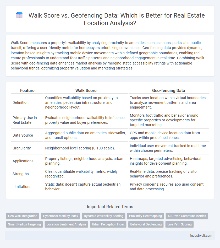
| Feature | Walk Score | Geo-fencing Data |
|---|---|---|
| Definition | Quantifies walkability based on proximity to amenities, pedestrian infrastructure, and neighborhood layout. | Tracks user location within virtual boundaries to analyze movement patterns and area engagement. |
| Primary Use in Real Estate | Evaluates neighborhood walkability to influence property value and buyer preferences. | Monitors foot traffic and behavior around specific properties or developments for targeted marketing. |
| Data Source | Aggregated public data on amenities, sidewalks, and transit options. | GPS and mobile device location data from apps within predefined zones. |
| Granularity | Neighborhood-level scoring (0-100 scale). | Individual user movement tracked in real-time within chosen perimeters. |
| Applications | Property listings, neighborhood analysis, urban planning. | Heatmaps, targeted advertising, behavioral insights for development planning. |
| Strengths | Clear, quantifiable walkability metric; widely recognized. | Real-time data; precise tracking of visitor behavior and preferences. |
| Limitations | Static data; doesn't capture actual pedestrian behavior. | Privacy concerns; requires app user consent and data processing. |
Introduction to Walk Score and Geo-fencing Data
Walk Score quantifies neighborhood walkability by analyzing the proximity and accessibility of amenities such as grocery stores, schools, and parks to a specific address, providing a numerical score that reflects pedestrian friendliness. Geo-fencing data utilizes GPS and RFID technology to create virtual boundaries around geographic areas, enabling real-time tracking and insights into foot traffic patterns within selected zones for real estate analysis. Both Walk Score and geo-fencing data enhance property valuation and marketing strategies by offering detailed information on location convenience and consumer movement trends.
Understanding Walk Score: Metrics and Impact
Walk Score measures neighborhood walkability based on proximity to amenities such as grocery stores, schools, parks, and public transit, assigning a score from 0 to 100 to indicate ease of pedestrian access. This metric influences property values by highlighting convenience and lifestyle quality, making it a key factor for real estate investors and homebuyers prioritizing urban accessibility. Geo-fencing data complements Walk Score by providing dynamic, location-based insights into foot traffic patterns and neighborhood engagement, enhancing targeted marketing and investment strategies.
What is Geo-fencing Data in Real Estate?
Geo-fencing data in real estate uses GPS and RFID technology to create virtual geographic boundaries, allowing realtors and developers to track and analyze property visitor patterns, neighborhood activity, and targeted marketing effectiveness. This data helps identify potential buyers' movements and preferences by monitoring entry and exit within defined perimeters, offering granular insights beyond traditional location metrics like Walk Score. Leveraging geo-fencing enhances property valuation, site selection, and personalized outreach by integrating real-time behavioral data with spatial analytics.
Data Sources: Walk Score vs Geo-fencing
Walk Score derives its data from public transit information, pedestrian pathways, and proximity to amenities such as grocery stores, restaurants, and parks, creating a composite score that measures walkability within a specific radius. Geo-fencing data relies on GPS signals, mobile device locations, and real-time movement patterns to define virtual boundaries around geographic areas, capturing precise user behavior and foot traffic within those zones. While Walk Score aggregates static environmental factors, geo-fencing offers dynamic, location-specific insights for real estate analysis and targeted marketing strategies.
Benefits of Walk Score for Real Estate Analysis
Walk Score provides a quantifiable measure of neighborhood walkability by analyzing proximity to amenities such as grocery stores, schools, and public transit, which enhances property valuation and buyer appeal. Incorporating Walk Score into real estate analysis allows investors and agents to identify high-demand locations with superior pedestrian access, leading to increased rental income and resale value. Unlike geo-fencing data, Walk Score offers a standardized, widely recognized metric that simplifies market comparison and supports smarter investment decisions.
Advantages of Geo-fencing Data for Property Insights
Geo-fencing data offers precise, real-time insights into property surroundings by tracking foot traffic patterns and consumer behavior within defined boundaries, enhancing market analysis beyond static Walk Score metrics. This dynamic approach allows real estate professionals to assess neighborhood activity trends, local business engagement, and potential for growth with higher accuracy. Utilizing geo-fencing data improves decision-making by providing actionable information on resident mobility and lifestyle preferences, critical for targeted property marketing and investment strategies.
Limitations and Challenges: Walk Score vs Geo-fencing
Walk Score provides a standardized measure of neighborhood walkability but often fails to capture real-time, dynamic changes in pedestrian patterns that geo-fencing data can offer. Geo-fencing data delivers granular insights into user movements and behavior within specific geographic boundaries, yet it faces challenges related to privacy concerns, data accuracy, and high implementation costs. Both methods have limitations in scalability and contextual relevance, making it essential to integrate multiple data sources for more precise real estate analysis.
Use Cases: When to Use Walk Score or Geo-fencing Data
Walk Score excels in real estate listings to highlight neighborhood walkability, attracting buyers prioritizing accessibility to amenities like shops, transit, and schools. Geo-fencing data is ideal for targeted marketing campaigns by defining specific geographic boundaries to reach potential buyers or renters in real-time. Use Walk Score for long-term lifestyle evaluations and geo-fencing for dynamic, location-based engagement strategies.
Integrating Walk Score and Geo-fencing for Deeper Insights
Integrating Walk Score with geo-fencing data provides a comprehensive view of neighborhood walkability by combining static walkability metrics with dynamic location-based behavior patterns. Real estate professionals can leverage this fusion to identify high-demand areas where residents frequently visit local amenities, improving property valuation accuracy and targeted marketing strategies. Utilizing both datasets enhances predictive analytics for urban development and investment decisions by capturing both environmental quality and actual user movement.
Future Trends in Location Data for Real Estate
Future trends in location data for real estate emphasize the integration of Walk Score with advanced geo-fencing data to enhance property valuation and consumer targeting. Geo-fencing enables hyper-localized marketing and real-time analytics, transforming how agents identify high-demand neighborhoods and tailor their listings. Combining these datasets offers predictive insights into urban mobility patterns, driving smarter investment decisions and personalized housing recommendations.
Related Important Terms
Geo-Walk Integration
Geo-Walk Integration combines Walk Score data with geo-fencing technology to enhance real estate insights by delivering precise, location-based walkability analytics tailored to specific neighborhoods. This integration enables developers and investors to assess pedestrian accessibility more accurately, improving property value predictions and targeted marketing strategies.
Hyperlocal Mobility Index
Walk Score offers a general measure of neighborhood walkability based on proximity to amenities, while geo-fencing data provides real-time, hyperlocal mobility patterns by tracking residents' movement within defined geographical boundaries. Combining these datasets enhances property valuation accuracy by integrating static walkability metrics with dynamic hyperlocal mobility indices reflecting actual pedestrian behavior.
Dynamic Walkability Scoring
Dynamic Walkability Scoring integrates real-time Geo-fencing Data to provide precise, context-aware Walk Scores that reflect actual pedestrian accessibility around properties. This advanced method enhances traditional Walk Scores by incorporating temporal and spatial variations, offering more accurate insights into neighborhood walkability for real estate evaluations.
Proximity Heatmapping
Walk Score quantifies walkability by measuring proximity to amenities, while geo-fencing data enables dynamic tracking of user movement within predefined virtual boundaries. Proximity heatmapping leverages geo-fencing data to visualize real-time foot traffic patterns and highlight high-demand neighborhoods, providing deeper insights than static Walk Score metrics.
AI-Driven Commute Metrics
AI-driven commute metrics combine Walk Score's pedestrian accessibility data with geo-fencing insights to deliver hyper-local, real-time analysis of daily travel patterns. Leveraging machine learning, this integration enhances property valuations and personalized neighborhood recommendations by accurately predicting commute times and lifestyle convenience.
Smart Radius Targeting
Walk Score quantifies neighborhood walkability by analyzing proximity to amenities, while geo-fencing data offers precise location tracking within defined boundaries for targeted marketing. Smart Radius Targeting leverages geo-fencing to dynamically adjust marketing efforts based on real-time movement patterns, enhancing lead accuracy and conversion rates in real estate campaigns.
Location Sentiment Analysis
Walk Score quantifies the pedestrian-friendliness of a property's location by analyzing proximity to amenities, while geo-fencing data captures real-time movement patterns and interactions within defined geographic boundaries, offering dynamic insights into neighborhood activity. Combining these metrics enhances location sentiment analysis by correlating static accessibility scores with actual user behaviors, providing a comprehensive evaluation of real estate desirability.
Urban Perception Index
Walk Score quantifies a neighborhood's walkability by measuring proximity to amenities, while Geo-fencing Data captures real-time location-based behavior and movement patterns within defined urban boundaries. The Urban Perception Index integrates both datasets to evaluate city livability by correlating pedestrian accessibility with actual foot traffic and user engagement levels.
Behavioral Geofencing
Behavioral geofencing leverages location-based data to analyze real-time consumer movement patterns, offering precise insights into property foot traffic and potential buyer behavior beyond traditional Walk Score metrics. Unlike Walk Score's static walkability rating, behavioral geofencing dynamically tracks engagement around real estate assets, enabling targeted marketing strategies tailored to actual user habits and preferences.
Live Path Scoring
Live Path Scoring leverages real-time Geo-fencing data to provide precise measurements of pedestrian accessibility, surpassing traditional Walk Score metrics that rely on static location attributes. This dynamic approach enhances property valuations by capturing actual walking patterns and neighborhood activity, offering investors and buyers a more accurate assessment of walkability.
Walk Score vs Geo-fencing Data Infographic