Site inspections involve physical presence to assess construction progress, identify safety hazards, and verify compliance with design specifications, providing hands-on insights that drones might miss. Drone surveys offer rapid, high-resolution aerial imagery and data collection over large areas, enhancing accuracy in mapping, volume measurement, and progress tracking without the risks associated with manual inspections. Combining both methods optimizes project management by leveraging detailed ground-level observations alongside comprehensive aerial perspectives.
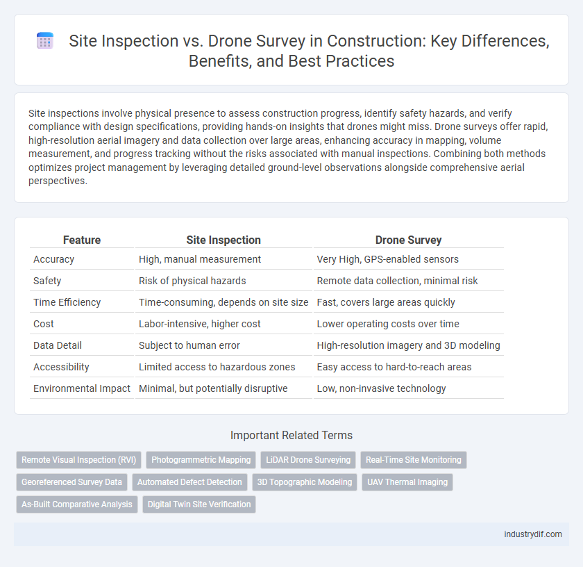
Table of Comparison
| Feature | Site Inspection | Drone Survey |
|---|---|---|
| Accuracy | High, manual measurement | Very High, GPS-enabled sensors |
| Safety | Risk of physical hazards | Remote data collection, minimal risk |
| Time Efficiency | Time-consuming, depends on site size | Fast, covers large areas quickly |
| Cost | Labor-intensive, higher cost | Lower operating costs over time |
| Data Detail | Subject to human error | High-resolution imagery and 3D modeling |
| Accessibility | Limited access to hazardous zones | Easy access to hard-to-reach areas |
| Environmental Impact | Minimal, but potentially disruptive | Low, non-invasive technology |
Understanding Site Inspection in Construction
Site inspection in construction involves a detailed, on-the-ground evaluation of a project site to assess progress, ensure compliance with design specifications, and identify potential safety hazards. It requires skilled professionals to manually examine structural elements, materials, and workmanship, providing critical insights that influence project timelines and quality control. Unlike drone surveys, site inspections offer direct human assessment, enabling real-time decision-making and immediate issue resolution.
What Is a Drone Survey?
A drone survey is an aerial data collection method using unmanned aerial vehicles (UAVs) equipped with high-resolution cameras and sensors to capture detailed images and topographical information of construction sites. This technology enables rapid, accurate mapping and real-time monitoring, improving site analysis compared to traditional ground-based inspections. Drone surveys enhance safety by accessing hard-to-reach areas and provide precise geospatial data for project planning and progress tracking.
Key Differences Between Site Inspection and Drone Survey
Site inspections involve on-ground, manual examination of construction progress, safety compliance, and material quality, providing detailed human observation essential for immediate issue identification. Drone surveys utilize aerial imaging technology to capture high-resolution photos and 3D models, enabling large-scale site analysis, topographic mapping, and progress monitoring from a bird's-eye view. Key differences include real-time human assessment versus remote automated data collection, precision in small area inspection versus broad site coverage, and the ability to access difficult or hazardous locations without physical presence.
Advantages of Traditional Site Inspections
Traditional site inspections provide direct, tactile assessment of construction progress, enabling immediate identification of safety hazards and quality issues. Experienced inspectors can evaluate structural details and workmanship nuances that drones might miss due to visual limitations and sensor constraints. Hands-on inspections facilitate real-time communication and collaboration among on-site personnel, enhancing decision-making accuracy and project management efficiency.
Benefits of Drone Surveys in Construction
Drone surveys in construction offer enhanced accuracy and efficiency by capturing high-resolution aerial imagery and 3D data that traditional site inspections may miss. They significantly reduce time and labor costs by covering large areas quickly while improving safety by minimizing the need for personnel to access hazardous or hard-to-reach locations. Real-time data integration from drone surveys enables more precise project monitoring, progress tracking, and early detection of potential issues.
Safety Implications: Manual vs. Drone Methods
Manual site inspections in construction expose workers to hazards such as unstable terrain, heavy machinery, and confined spaces, increasing the risk of accidents and injuries. Drone surveys eliminate the need for personnel to access dangerous areas, enhancing safety by providing high-resolution aerial data remotely. Integrating drone technology reduces onsite human exposure while delivering precise, real-time site assessments critical for hazard identification and risk management.
Accuracy and Data Collection: A Comparative Analysis
Site inspections provide detailed visual assessments through direct human observation, ensuring accuracy in identifying structural issues and compliance with safety standards. Drone surveys enhance data collection by capturing high-resolution aerial imagery and 3D models, enabling comprehensive site analysis and real-time monitoring over large areas. Combining both methods maximizes precision and efficiency, as drones offer rapid data gathering while on-site inspections validate findings with expert judgment.
Cost Considerations: Site Inspection vs. Drone Survey
Traditional site inspections often incur higher labor costs and extended project timelines due to manual measurements and safety precautions. Drone surveys reduce operational expenses by quickly capturing high-resolution aerial data, minimizing the need for extensive on-site personnel. Investing in drone technology lowers long-term costs through faster data acquisition and improved accuracy, optimizing budget allocation for construction projects.
Real-World Applications and Case Studies
Site inspections involve direct, on-the-ground evaluations of construction progress, safety compliance, and quality control, providing detailed visual and tactile information critical for complex assessments. Drone surveys offer rapid, aerial data collection with high-resolution imaging, enabling accurate topographic mapping, volume calculations, and real-time progress monitoring over large construction sites. Case studies in urban infrastructure projects demonstrate drones reducing inspection time by up to 70%, while traditional site inspections remain essential for detailed structural evaluations and risk assessments.
Future Trends in Construction Site Assessment
Future trends in construction site assessment highlight increasing reliance on drone surveys for real-time data collection, offering enhanced accuracy and efficiency over traditional site inspections. Integration of AI-powered analytics with drone imagery enables predictive maintenance and risk identification, transforming project management practices. Emerging technologies also promote sustainable construction by monitoring environmental impact and compliance through precise, automated site evaluations.
Related Important Terms
Remote Visual Inspection (RVI)
Remote Visual Inspection (RVI) in construction leverages drones equipped with high-resolution cameras to conduct site surveys, offering detailed aerial views that enhance safety and efficiency compared to traditional site inspections. This technology enables real-time data collection and precise monitoring of hard-to-reach areas, reducing the need for physical presence and accelerating project timelines.
Photogrammetric Mapping
Site inspections provide on-ground visual assessments crucial for identifying structural issues, while drone surveys utilize photogrammetric mapping to generate high-resolution, geospatial 3D models for accurate site analysis and progress monitoring. Photogrammetric mapping enhances construction efficiency by enabling precise measurements, volume calculations, and real-time data sharing without the safety risks associated with traditional manual inspections.
LiDAR Drone Surveying
LiDAR drone surveying offers precise 3D mapping and terrain modeling capabilities far beyond traditional site inspection methods, enabling faster data collection over large construction sites with high accuracy. Unlike manual site inspections, LiDAR drones capture detailed topographic and volumetric information essential for project planning, progress monitoring, and risk assessment in construction management.
Real-Time Site Monitoring
Site inspection offers direct human observation but is limited by accessibility and time constraints, whereas drone surveys provide real-time site monitoring with high-resolution aerial imagery, enabling rapid identification of site issues and enhanced project management. Drone technology improves data accuracy and frequency, supporting efficient decision-making and reducing delays in construction workflows.
Georeferenced Survey Data
Site inspections provide visual and physical assessments of construction progress, but drone surveys deliver high-resolution, georeferenced survey data that enhances accuracy and spatial analysis. Georeferenced drone data enables precise mapping of site conditions, supports real-time monitoring, and improves decision-making through comprehensive 3D models and orthomosaics.
Automated Defect Detection
Automated defect detection through drone surveys enhances site inspection accuracy by rapidly capturing high-resolution images and identifying structural issues using AI algorithms. Traditional site inspections rely on manual observation, which is time-consuming and prone to human error, whereas drone surveys provide efficient, precise, and comprehensive defect analysis in construction projects.
3D Topographic Modeling
Site inspection provides detailed visual assessments, while drone surveys capture precise aerial data, enabling accurate 3D topographic modeling for construction projects. Drone-based 3D models enhance terrain analysis, improve project planning, and reduce time and costs compared to traditional site inspections.
UAV Thermal Imaging
UAV thermal imaging enhances site inspections by providing precise temperature mapping to detect structural anomalies, moisture intrusion, and electrical faults, which traditional site inspections may overlook. Drone surveys equipped with thermal cameras accelerate data collection, improving accuracy in identifying heat loss, insulation defects, and equipment overheating on construction sites.
As-Built Comparative Analysis
Site inspections provide detailed, on-the-ground observations for as-built comparative analysis, capturing precise physical conditions and potential discrepancies. Drone surveys offer high-resolution aerial imagery and 3D mapping, enabling efficient, large-scale data collection and accurate digital overlays for comprehensive as-built comparisons.
Digital Twin Site Verification
Site inspection involves manual monitoring of construction progress, providing direct, on-ground data for Digital Twin site verification, while drone surveys offer high-resolution aerial imagery and real-time 3D mapping to enhance accuracy and efficiency in tracking site changes. Integrating drone survey data with digital twin technology accelerates clash detection and project coordination by delivering comprehensive spatial insights.
Site Inspection vs Drone Survey Infographic