Traditional surveying relies on manual measurements and physical markers to collect accurate spatial data, often requiring significant time and labor on-site. Drone mapping uses aerial imagery and advanced sensors to rapidly capture high-resolution data, providing detailed topographic maps and 3D models with enhanced efficiency. Combining drone technology with traditional methods improves precision, reduces costs, and accelerates project timelines in construction site analysis.
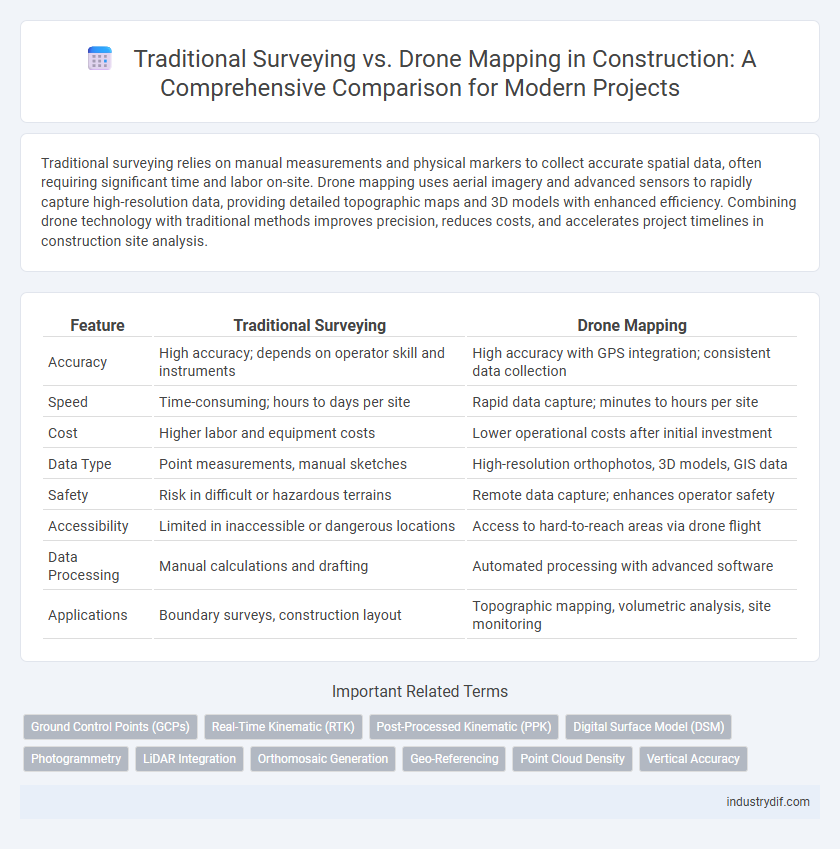
Table of Comparison
| Feature | Traditional Surveying | Drone Mapping |
|---|---|---|
| Accuracy | High accuracy; depends on operator skill and instruments | High accuracy with GPS integration; consistent data collection |
| Speed | Time-consuming; hours to days per site | Rapid data capture; minutes to hours per site |
| Cost | Higher labor and equipment costs | Lower operational costs after initial investment |
| Data Type | Point measurements, manual sketches | High-resolution orthophotos, 3D models, GIS data |
| Safety | Risk in difficult or hazardous terrains | Remote data capture; enhances operator safety |
| Accessibility | Limited in inaccessible or dangerous locations | Access to hard-to-reach areas via drone flight |
| Data Processing | Manual calculations and drafting | Automated processing with advanced software |
| Applications | Boundary surveys, construction layout | Topographic mapping, volumetric analysis, site monitoring |
Introduction to Surveying Methods in Construction
Traditional surveying in construction relies on manual measurements using tools like theodolites and total stations, providing high accuracy but requiring significant time and labor. Drone mapping employs UAVs equipped with high-resolution cameras and GPS to capture aerial data rapidly, enabling detailed 3D models and topographic maps. Combining both methods enhances site analysis by balancing precision with efficiency, optimizing project planning and execution.
Overview of Traditional Surveying Techniques
Traditional surveying techniques in construction rely on tools such as theodolites, total stations, and leveling instruments to measure angles, distances, and elevations with high accuracy. Surveyors manually collect data on-site through line-of-sight observations and geometric calculations, establishing control points for project layouts. These time-tested methods provide precise topographical information but often require more labor and longer timeframes compared to modern drone mapping technologies.
Drone Mapping: Modern Surveying Explained
Drone mapping revolutionizes construction surveying by providing rapid, accurate aerial data collection, enabling precise topographic mapping and volumetric analysis with high-resolution imaging. Unlike traditional surveying methods that rely on manual measurements and limited viewpoints, drone mapping captures extensive terrain details efficiently, reducing labor costs and minimizing human error. The integration of GIS and photogrammetry software with drone technology enhances real-time project monitoring, facilitating better decision-making and accelerating construction timelines.
Accuracy Comparison: Traditional vs Drone Mapping
Traditional surveying relies on ground-based measurements using total stations and theodolites, providing high precision for small to medium-scale projects with accuracy typically within a few millimeters. Drone mapping employs aerial photogrammetry and LiDAR sensors to capture large areas quickly, with accuracy often ranging from 2 to 10 centimeters depending on flight altitude and sensor quality. While traditional methods excel in point-specific accuracy, drone mapping offers efficient data collection with acceptable accuracy for broader site analysis and topographic mapping in construction projects.
Speed and Efficiency in Surveying Workflows
Traditional surveying methods often require extensive manual labor and longer timeframes to collect accurate spatial data. Drone mapping leverages advanced aerial technology and high-resolution sensors to capture large areas rapidly, significantly accelerating data acquisition and processing. This shift improves overall efficiency in surveying workflows by reducing field time, minimizing human error, and enabling faster project decision-making in construction sites.
Cost-Effectiveness: Investment and Operational Costs
Traditional surveying demands significant investment in equipment like total stations and GPS units, alongside higher labor expenses due to the need for skilled personnel and longer field times. Drone mapping reduces operational costs through faster data collection, minimal manpower, and lower equipment maintenance, offering high-resolution imagery and 3D models efficiently. Overall, drone mapping presents a cost-effective alternative by lowering both upfront investment and ongoing operational expenses in construction site surveying.
Safety Considerations in Surveying Practices
Traditional surveying in construction poses higher safety risks due to manual measurements in hazardous terrains, whereas drone mapping significantly reduces on-site personnel exposure by capturing high-resolution data remotely. Drones equipped with LiDAR and photogrammetry improve accuracy while mitigating accidents related to uneven ground, heavy machinery, and confined spaces. Integrating drone technology aligns with occupational safety standards, enhancing survey efficiency and minimizing workplace injuries.
Data Output and Visualization Capabilities
Traditional surveying provides highly accurate point measurements with limited spatial coverage, often requiring manual data processing to generate maps and plans. Drone mapping captures extensive aerial imagery to produce detailed orthomosaics, 3D models, and topographic maps, enabling rapid data visualization and comprehensive site analysis. Advanced software integrates drone data to facilitate real-time monitoring, improving decision-making and project management efficiency in construction.
Limitations and Challenges of Each Surveying Method
Traditional surveying faces limitations such as time-consuming data collection, difficulty accessing hazardous or remote areas, and reliance on manual measurements prone to human error. Drone mapping overcomes many access challenges and accelerates data acquisition but encounters issues like battery life constraints, regulatory restrictions, and lower accuracy in dense urban environments with GPS signal interference. Both methods require expertise to interpret data correctly, with traditional surveyors needing extensive field experience and drone operators requiring technical skills in photogrammetry and data processing.
Choosing the Right Surveying Approach for Your Project
Selecting the appropriate surveying approach depends on project scope, budget, and accuracy requirements. Traditional surveying offers high precision for small to medium sites with complex topography, while drone mapping excels in large-scale, time-sensitive projects by providing rapid data collection and 3D terrain models. Integrating both methods can optimize accuracy and efficiency, ensuring detailed site analysis and informed decision-making throughout construction phases.
Related Important Terms
Ground Control Points (GCPs)
Ground Control Points (GCPs) are essential in both traditional surveying and drone mapping to ensure spatial accuracy, with traditional surveying relying on physically established GCPs marked by surveyors, while drone mapping uses GPS coordinates enhanced by GCPs for precise georeferencing. Incorporating high-quality GCPs significantly reduces errors in drone-generated orthomosaics and 3D models, aligning them closely with the accuracy levels of conventional ground surveys.
Real-Time Kinematic (RTK)
Real-Time Kinematic (RTK) technology in drone mapping offers centimeter-level accuracy by utilizing satellite base stations and real-time corrections, surpassing traditional surveying methods that rely heavily on manual measurements and baseline GPS data. This enhanced precision accelerates construction site analysis, reduces human error, and significantly improves project efficiency compared to conventional approaches.
Post-Processed Kinematic (PPK)
Post-Processed Kinematic (PPK) technology enhances drone mapping accuracy by correcting GPS data after flight, providing precise geospatial measurements essential for construction site surveys. Unlike traditional surveying, which relies on manual data collection and static equipment, PPK-enabled drones deliver faster, high-resolution topographic maps that streamline project planning and reduce field time.
Digital Surface Model (DSM)
Traditional surveying methods rely on ground-based measurements to create Digital Surface Models (DSMs) but often require more time and labor compared to drone mapping, which utilizes aerial imagery and photogrammetry for faster, high-resolution DSM generation. Drone mapping captures comprehensive topographic data over large construction sites with increased accuracy, enhancing project planning and monitoring efficiency.
Photogrammetry
Traditional surveying relies on manual measurements and ground-based equipment, offering high accuracy but limited spatial coverage and slower data collection. Drone mapping with photogrammetry captures high-resolution aerial images rapidly, enabling precise 3D models and volumetric calculations essential for modern construction project planning and monitoring.
LiDAR Integration
Traditional surveying relies on manual measurements and optical instruments, offering high accuracy but limited speed and coverage. Drone mapping with LiDAR integration enhances construction site analysis by providing rapid, precise, and high-resolution 3D data, significantly improving topographic modeling and reducing time and labor costs.
Orthomosaic Generation
Traditional surveying relies on ground-based measurements and manual data collection, resulting in slower orthomosaic generation with limited coverage and resolution. Drone mapping accelerates orthomosaic production by capturing high-resolution aerial images over large areas, enabling precise georeferenced mosaics essential for construction site monitoring and planning.
Geo-Referencing
Traditional surveying relies on ground control points and manual measurements for geo-referencing, which can be time-consuming and prone to human error. Drone mapping utilizes GPS and real-time kinematic (RTK) technology to achieve highly accurate geo-referenced data quickly, enhancing spatial precision in construction projects.
Point Cloud Density
Traditional surveying methods typically generate lower point cloud density due to limited data capture from ground-based instruments, resulting in less detailed 3D models. Drone mapping employs high-resolution sensors and aerial perspectives to produce denser point clouds, enhancing accuracy and spatial detail for construction site analysis.
Vertical Accuracy
Traditional surveying methods typically achieve vertical accuracy within a few millimeters to centimeters, relying on precise instruments such as total stations and leveling rods for elevation measurements. Drone mapping can provide vertical accuracy ranging from 5 to 15 centimeters depending on factors like flight altitude, sensor quality, and Ground Control Point (GCP) placement, making it suitable for rapid topographic surveys but often less precise than traditional techniques.
Traditional Surveying vs Drone Mapping Infographic