Exploration in mining relies heavily on traditional methods such as field sampling and geophysical surveys to identify mineral-rich areas. Drones enhance geological surveys by providing high-resolution aerial imagery and real-time data collection, improving the accuracy and efficiency of mapping large, difficult terrains. Integrating drones with conventional exploration techniques accelerates site evaluation and reduces operational risks.
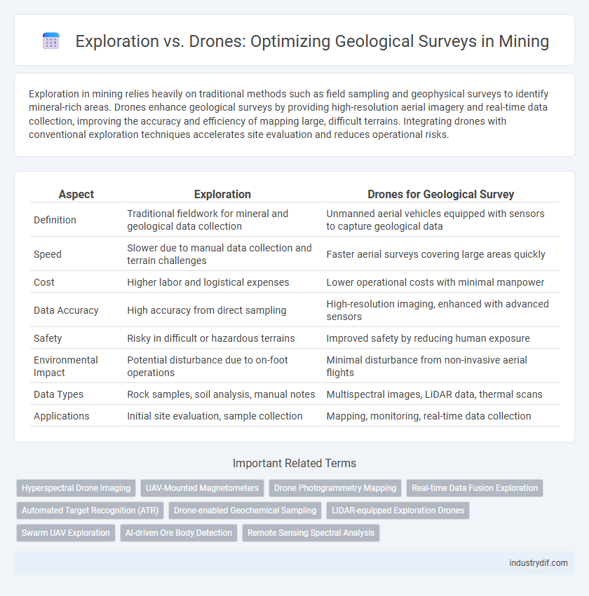
Table of Comparison
| Aspect | Exploration | Drones for Geological Survey |
|---|---|---|
| Definition | Traditional fieldwork for mineral and geological data collection | Unmanned aerial vehicles equipped with sensors to capture geological data |
| Speed | Slower due to manual data collection and terrain challenges | Faster aerial surveys covering large areas quickly |
| Cost | Higher labor and logistical expenses | Lower operational costs with minimal manpower |
| Data Accuracy | High accuracy from direct sampling | High-resolution imaging, enhanced with advanced sensors |
| Safety | Risky in difficult or hazardous terrains | Improved safety by reducing human exposure |
| Environmental Impact | Potential disturbance due to on-foot operations | Minimal disturbance from non-invasive aerial flights |
| Data Types | Rock samples, soil analysis, manual notes | Multispectral images, LiDAR data, thermal scans |
| Applications | Initial site evaluation, sample collection | Mapping, monitoring, real-time data collection |
Introduction to Geological Survey Methods in Mining
Geological survey methods in mining encompass traditional exploration techniques such as field mapping, sampling, and geophysical measurements to identify mineral deposits. The integration of drones enhances these surveys by providing high-resolution aerial imagery, topographic data, and remote sensing capabilities that improve accuracy and reduce survey time. Combining conventional exploration with drone technology optimizes data collection, accelerates decision-making, and lowers operational costs in mineral exploration projects.
Traditional Exploration Techniques in Mineral Discovery
Traditional exploration techniques in mineral discovery rely heavily on fieldwork, including rock sampling, geological mapping, and geophysical surveys to assess mineral potential. These methods provide direct, precise data essential for identifying ore bodies but often require extensive time, manpower, and access to difficult terrain. Despite advancements in drone technology, conventional techniques remain fundamental for validating mineral deposits through hands-on investigation and detailed geological analysis.
The Rise of Drone Technology in Geological Surveys
Drone technology has revolutionized geological surveys by providing high-resolution aerial imagery and precise topographical data, significantly reducing the time and costs associated with traditional exploration methods. Equipped with advanced sensors such as LiDAR and multispectral cameras, drones enable real-time data collection over difficult and remote mining sites, enhancing accuracy and safety in mineral prospecting. The integration of drone-based surveys accelerates resource identification and environmental monitoring, driving efficiency in the mining exploration process.
Key Differences Between Manual Exploration and Drone Surveys
Manual exploration relies on on-the-ground geologists conducting physical sampling and mapping, providing detailed but time-consuming data collection. Drone surveys use aerial technology equipped with high-resolution cameras and sensors, enabling rapid, large-area data acquisition with precise topographical and mineralogical insights. The key differences include speed, scale, and data accuracy, where drones offer efficient coverage and real-time monitoring, while manual methods deliver in-depth contextual analysis through direct human observation.
Accuracy and Data Quality: Drones vs Traditional Exploration
Drones offer superior accuracy and higher-resolution data quality compared to traditional mining exploration methods by capturing detailed aerial imagery and real-time geospatial information. Their ability to access difficult terrains enhances geological survey precision, reducing human error and improving data consistency. Traditional exploration, while proven, often relies on slower, ground-based observations that may miss subtle variations detectable through drone technology.
Cost-Efficiency Analysis: Exploring with Drones versus Standard Methods
Exploration using drones for geological surveys significantly reduces operational costs by minimizing the need for extensive ground personnel and expensive heavy machinery typical in traditional methods. Drones provide high-resolution aerial data more rapidly, enabling precise site mapping that accelerates decision-making and reduces total project time. Integrating drone technology in exploration workflows enhances cost-efficiency, offering a scalable solution that lowers logistical expenses and improves resource allocation compared to standard exploration techniques.
Safety Implications: Human Surveyors vs Unmanned Aerial Vehicles
Drones in geological surveys significantly reduce risks to human surveyors by accessing hazardous or unstable terrain without physical presence, minimizing exposure to landslides, toxic gases, and extreme weather. Unmanned Aerial Vehicles (UAVs) provide real-time data collection with precision sensors, enhancing safety protocols through remote operation and rapid hazard identification. Human surveyors face increased dangers from environmental unpredictability and manual sampling, whereas drones improve overall safety by enabling thorough, efficient exploration with reduced on-site human intervention.
Environmental Impact of Drones and Traditional Exploration Approaches
Drones significantly reduce the environmental impact of geological surveys by minimizing land disturbance, vegetation damage, and carbon emissions compared to traditional exploration methods involving heavy machinery and extensive fieldwork. Traditional exploration techniques often cause soil erosion, habitat disruption, and increased fuel consumption, whereas drone-based surveys provide precise, real-time data with minimal ecological footprint. Implementing drone technology in mining exploration enhances sustainability by enabling remote sensing, reducing the need for large-scale physical intrusion into sensitive environments.
Case Studies: Successful Drone Applications in Mining Exploration
Case studies demonstrate that drones significantly enhance geological survey accuracy and efficiency in mining exploration by capturing high-resolution aerial imagery and real-time topographic data. In gold mining regions like Nevada, UAV-based photogrammetry has reduced survey time by 50% while improving deposit modeling precision. The integration of multispectral and LiDAR sensors on drones provides critical mineral composition insights, leading to more informed decision-making and cost savings in exploration projects.
Future Trends: Integrating Drones into Geoscientific Exploration
Drones are revolutionizing geological surveys by providing high-resolution aerial data that enhances mineral exploration accuracy and efficiency. Emerging technologies integrate multispectral and hyperspectral sensors with drones, enabling real-time analysis of geological formations and mineral deposits. Future trends emphasize autonomous drone swarms conducting extensive geoscientific exploration, reducing operational costs and environmental impact while improving data precision.
Related Important Terms
Hyperspectral Drone Imaging
Hyperspectral drone imaging revolutionizes geological surveys by capturing detailed spectral data across numerous wavelengths, enabling precise mineral identification and mapping compared to traditional exploration methods. This technology enhances efficiency, reduces field time, and improves data accuracy for mining companies seeking to optimize resource extraction.
UAV-Mounted Magnetometers
UAV-mounted magnetometers significantly enhance geological survey accuracy by detecting subtle magnetic anomalies otherwise missed in traditional exploration methods, enabling efficient mineral deposit identification. These drones reduce operational costs and increase data collection speed, transforming survey logistics in mining exploration with real-time geospatial mapping capabilities.
Drone Photogrammetry Mapping
Drone photogrammetry mapping revolutionizes geological surveys by efficiently capturing high-resolution aerial imagery to create detailed 3D terrain models, significantly enhancing mineral exploration accuracy. This technology reduces field time and operational costs compared to traditional exploration methods, enabling rapid identification of geological features and resource deposits.
Real-time Data Fusion Exploration
Real-time data fusion in geological survey integrates drone-collected multispectral and LiDAR data with traditional exploration methods, enhancing mineral detection accuracy and reducing survey time by up to 40%. This synergy allows for dynamic mapping and immediate analysis, enabling faster decision-making and optimizing resource allocation in mining operations.
Automated Target Recognition (ATR)
Automated Target Recognition (ATR) in mining leverages drone technology to enhance geological surveys by rapidly identifying mineral deposits and geological features with high precision and reduced human intervention. This integration streamlines exploration processes, increases data accuracy, and enables real-time decision-making in remote or hazardous mining environments.
Drone-enabled Geochemical Sampling
Drone-enabled geochemical sampling revolutionizes geological surveys by providing precise, real-time data collection in hard-to-reach mining sites, significantly enhancing exploration efficiency and reducing operational costs. Integration of drone technology with advanced sensors facilitates rapid mapping of mineral deposits, improving resource estimation accuracy and minimizing environmental impact compared to traditional exploration methods.
LIDAR-equipped Exploration Drones
LIDAR-equipped exploration drones revolutionize geological surveys by providing high-resolution 3D terrain mapping with unprecedented accuracy and efficiency, significantly reducing the time and cost compared to traditional manual exploration methods. These drones rapidly identify mineral deposits and geological features, enabling more precise targeting and enhanced decision-making in mining exploration projects.
Swarm UAV Exploration
Swarm UAV exploration in geological surveys enables simultaneous data collection over extensive mining areas, increasing efficiency and accuracy compared to traditional exploration methods. These drone swarms provide real-time topographical mapping and mineral detection, significantly reducing operational costs and environmental impact in mining exploration.
AI-driven Ore Body Detection
AI-driven ore body detection leverages drones equipped with advanced sensors and machine learning algorithms, enabling rapid, high-resolution geological surveys that outperform traditional exploration methods in accuracy and efficiency. This technology enhances mineral identification and mapping, reducing operational costs and environmental impact while accelerating decision-making in mining exploration.
Remote Sensing Spectral Analysis
Remote sensing spectral analysis integrates hyperspectral imaging from drones, enabling precise mineral identification and mapping of geological formations with high spatial resolution. This technology significantly enhances exploration efficiency by providing real-time, cost-effective data acquisition compared to traditional ground-based surveys.
Exploration vs Drones for Geological Survey Infographic